 Filter: Categories of Wisconsin Historical Images
Filter: Subject of State parks and reserves
Filter: Year of 2000-Present
Filter: Subject of land
Filter: Categories of Wisconsin Historical Images
Filter: Subject of State parks and reserves
Filter: Year of 2000-Present
Filter: Subject of land

| Date: | 2000 |
|---|---|
| Description: | This map shows national parks, county and state forests, Indian reservations, municipal land, private land, docks, boat access, camping, and points of inte... |
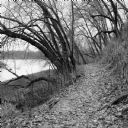
| Date: | 11 2013 |
|---|---|
| Description: | View down a small dirt path lined with grasses and trees along Ferry Bluff State Natural Area. To the left is Honey Creek leading to the Wisconsin River. |
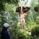
| Date: | 08 24 2014 |
|---|---|
| Description: | View from walkway of Stand Rock rising out of the bushes and trees surrounding the geological formation. A net is strung low between Stand Rock and the nea... |

| Date: | 09 07 2014 |
|---|---|
| Description: | View from the top of a hill looking out to a valley, with clouds in the blue sky. Trees are framing the view, and in the foreground, a woman, the photograp... |
If you didn't find the material you searched for, our Library Reference Staff can help.
Call our reference desk at 608-264-6535 or email us at: