 Filter: Categories of Wisconsin Historical Images
Filter: Subject of State parks and reserves
Filter: Year of 1900-1999
Filter: Year of 1980-1989
Filter: Categories of Wisconsin Historical Images
Filter: Subject of State parks and reserves
Filter: Year of 1900-1999
Filter: Year of 1980-1989

| Date: | 1981 |
|---|---|
| Description: | Plat map of Madeline Island surrounded by Basswood, Michigan and Gull Islands. |

| Date: | 1987 |
|---|---|
| Description: | This 1987 map of Door County, Wisconsin, shows streets and roads, cities and villages, state parks, lakes and streams, and depths in Lake Michigan. A stree... |

| Date: | 1980 |
|---|---|
| Description: | This map shows the locations of 42 businesses, roads, points of interest, recreation sites, camping, the North Country Trail and parking, and boundaries of... |

| Date: | 1987 |
|---|---|
| Description: | This map shows federal highways, state or county highways, rivers, lakes, town roads, township boundaries, county boundaries, national or state forest, loo... |

| Date: | 1987 |
|---|---|
| Description: | This map shows county forests, state, federal, and interstate highways. County forests lands are shown in light green. The front of the map includes images... |

| Date: | 1980 |
|---|---|
| Description: | A close-up view of the gnarled trunk of a large bur oak located in Kettle Moraine State Park. The trunk is distorted by scars and burls. |
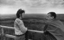
| Date: | 06 01 1983 |
|---|---|
| Description: | Two people are leaning against a railing overlooking at forest. Caption reads: "Rachel Imsland, 25, and Mark Evans, 28, both of Iowa City, Iowa, viewed the... |
If you didn't find the material you searched for, our Library Reference Staff can help.
Call our reference desk at 608-264-6535 or email us at: