 Filter: Categories of Wisconsin Historical Images
Filter: Subject of State parks and reserves
Filter: Year of 1900-1999
Filter: Year of 1970-1979
Filter: Categories of Wisconsin Historical Images
Filter: Subject of State parks and reserves
Filter: Year of 1900-1999
Filter: Year of 1970-1979

| Date: | 04 14 1974 |
|---|---|
| Description: | View of the Tenney Park bridge casting a reflection in the water of the lagoon. |
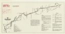
| Date: | 08 1976 |
|---|---|
| Description: | A map that shows the trail route and detours from Rice Lake, in Barron County, through Washburn and Sawyer counties, to Park Falls, in Price County. A mile... |

| Date: | 1975 |
|---|---|
| Description: | A tourist map of Grant County that displays the various activities and attractions found in the cities throughout the county, such as boat landings, fishin... |
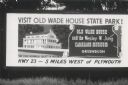
| Date: | 1971 |
|---|---|
| Description: | An advertising billboard for Old Wade House and the Wesley W. Jung Carriage Museum. |

| Date: | 1971 |
|---|---|
| Description: | This map of Nelson Dewey State Park shows the park layout, points of interest, facilities, campgrounds, roads, railroads, and the Mississippi River. Relief... |

| Date: | 1975 |
|---|---|
| Description: | This standard U.S.G.S. topographic map was annotated by civil engineer and railroad historian James P. Kaysen to show the location of existing and defunct ... |

| Date: | 1973 |
|---|---|
| Description: | This map shows cities, historical markers, interstate highways, U.S. highways, state highways, state parks and state forests. The original caption reads, "... |

| Date: | 1970 |
|---|---|
| Description: | This colored map displays a brief description of tourist attractions in the state, as well as a grid of state parks and recreational facilities. There is a... |

| Date: | 10 1978 |
|---|---|
| Description: | Melvin and Sadie Tvedt, of Mount Horeb, standing at the railing looking towards the left on a wooden bridge in Governor Dodge State Park. The trees around ... |
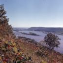
| Date: | 1972 |
|---|---|
| Description: | Elevated view looking south towards the Mississippi River from Brady's Bluff in Perrot State Park. |

| Date: | 11 1976 |
|---|---|
| Description: | Two men wearing red and orange clothing are kneeling on the ground and posing with their bucks in front of a trailer. |
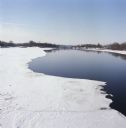
| Date: | 03 1978 |
|---|---|
| Description: | Elevated view of Wisconsin River. Snow and ice is covering part of the river, and in the distance is a bridge over the river. |

| Date: | 10 1978 |
|---|---|
| Description: | Melvin and Sadie Tvedt of Mount Horeb, walking out of the woods and across a small wooden bridge. In the foreground is a roofed bench with a sign reading: ... |
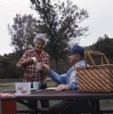
| Date: | 10 1978 |
|---|---|
| Description: | Sadie Tvedt of Mount Horeb, standing and pouring from a thermos liquid into her husband Melvin's cup. A plastic container of food and a picnic basket are s... |

| Date: | 10 1978 |
|---|---|
| Description: | Melvin and Sadie Tvedt of Mount Horeb, walking down a trail at Governor Dodge State Park. |

| Date: | 1970 |
|---|---|
| Description: | New snow on the steps at Devil's Lake, with a broom leaning on the hand rail. Trees are in the background. |
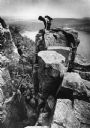
| Date: | 1976 |
|---|---|
| Description: | View towards a rock climber on top of an outcropping at Devil's Lake State Park who is watching another climber descending. Devil's Lake and bluffs are in ... |
If you didn't find the material you searched for, our Library Reference Staff can help.
Call our reference desk at 608-264-6535 or email us at: