 Filter: Categories of Wisconsin Historical Images
Filter: Subject of State parks and reserves
Filter: Subject of water
Filter: Categories of Wisconsin Historical Images
Filter: Subject of State parks and reserves
Filter: Subject of water

| Date: | 1936 |
|---|---|
| Description: | This map shows the state trunk highway system and county trunk highways. This map show surface type on state and county trunk highways and the locations of... |

| Date: | 1939 |
|---|---|
| Description: | This map shows the state trunk highway system and county trunk highways. This map show surface type on state and county trunk highways and the locations of... |

| Date: | 1952 |
|---|---|
| Description: | This map shows roads, foot and canoe trails, railroads, resorts, lookout towers, camps, national and state forests, Indian reservation, and types of fish i... |

| Date: | 03 31 1965 |
|---|---|
| Description: | Nature view with marshland sedges and rushes in foreground, Lake Kegonsa, and a tree-lined horizon. The newly acquired area consists of marsh, woodland, In... |

| Date: | |
|---|---|
| Description: | View from shoreline over a marshy area towards a lake at Northern Lakes Park. There is a tree-covered shoreline in the far background. There may be an isl... |

| Date: | |
|---|---|
| Description: | View through the pines of Round Lake and far shoreline at Northern Lakes Park. |

| Date: | |
|---|---|
| Description: | Elevated view looking across towards Big Manitou Falls, a waterfall in Pattison State Park. The falls are surrounded by trees and rocks. Pattison State Par... |
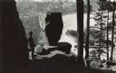
| Date: | |
|---|---|
| Description: | Elevated view of a man standing on a rock looking over a frozen Devil's Lake in front of a Balanced Rock. Original caption: "There are some startling rock ... |

| Date: | 1940 |
|---|---|
| Description: | This pictorial map shows points of interest, recreation activities, and highways in the vicinity of the restaurant and covers the Wisconsin River Valley be... |

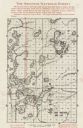
| Date: | 2000 |
|---|---|
| Description: | This map shows national parks, county and state forests, Indian reservations, municipal land, private land, docks, boat access, camping, and points of inte... |
| Date: | 1935 |
|---|---|
| Description: | This map shows land for sale by the company in northwestern part of Nicolet National Forest. The map also shows shoreline acreages, railroads, roads, trail... |

| Date: | 1926 |
|---|---|
| Description: | This map shows road surfacings, camp sites, state parks, proposed state parks, rivers, lakes, county boundaries, and cities. Includes portions of Minnesota... |

| Date: | 1987 |
|---|---|
| Description: | This map shows federal highways, state or county highways, rivers, lakes, town roads, township boundaries, county boundaries, national or state forest, loo... |

| Date: | 1936 |
|---|---|
| Description: | This map shows campsites, trails, auto roads, surrounding townships, and points of interest, by including pictorial illustrations. Includes an inserted map... |

| Date: | 1949 |
|---|---|
| Description: | This map shows points of interest, historic sites, buildings, trails, roads, and general animal and plant locations. |
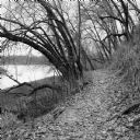
| Date: | 11 2013 |
|---|---|
| Description: | View down a small dirt path lined with grasses and trees along Ferry Bluff State Natural Area. To the left is Honey Creek leading to the Wisconsin River. |
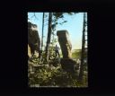
| Date: | 08 26 1913 |
|---|---|
| Description: | View through trees towards a man posing next to a large rock formation of a balancing rock. On the right is another rock formation. Below in the background... |

| Date: | 1930 |
|---|---|
| Description: | This map shows the entire state plus portions of Illinois, Iowa, Minnesota, and Michigan outlined in blue. The map shows roads, state parks (black triangle... |

| Date: | 1929 |
|---|---|
| Description: | This map of the entire state includes portions of Illinois, Iowa, Michigan, and Minnesota. The map shows U.S., state, and county highways, roads, campsites... |

| Date: | 1925 |
|---|---|
| Description: | The map shows the entire state with portions of Illinois, Iowa, Minnesota, and Michigan. The map shows concrete, gravel, all weather earth, clay, and sand ... |
If you didn't find the material you searched for, our Library Reference Staff can help.
Call our reference desk at 608-264-6535 or email us at: