 Filter: Categories of Wisconsin Historical Images
Filter: Subject of State parks and reserves
Filter: Subject of water
Filter: Categories of Wisconsin Historical Images
Filter: Subject of State parks and reserves
Filter: Subject of water

| Date: | 1915 |
|---|---|
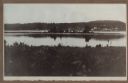
| Description: | Elevated view over a heavily wooded area to Fish Creek Harbor and Hen Island, with Peninsula State Park in the background. |

| Date: | 1915 |
|---|---|
| Description: | Birch and evergreen trees line the rocky shore of Toft Point, with Cana Island and its lighthouse in the background. |

| Date: | 1991 |
|---|---|
| Description: | This 1991 map of Burnett County, Wisconsin, shows Governor Knowles State Forest, wildlife areas, public hunting grounds, and other outdoor recreation facil... |
| Date: | 1915 |
|---|---|
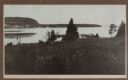
| Description: | Hen Island is reflected in the water of Fish Creek Bay in this view from Nelson Point in Peninsula State Park. The homes and businesses of Fish Creek are i... |
| Date: | 1915 |
|---|---|
| Description: | View down hill towards a man fishing from the pier at Nelson Point in Peninsula State Park. Fish Creek is seen across the bay. Dr. Welcker's Casino is the ... |
| Date: | 1893 |
|---|---|
| Description: | A bird’s-eye view map. Inset maps read: Honey Creek Basin and Baraboo Bluffs -- Sauk County -- The ancient Green Bay glacier. Includes distant chart, eleva... |

| Date: | 1923 |
|---|---|
| Description: | This topographical map of Devil's Lake State Park, Sauk County, Wisconsin, is based on 1922-1923 surveys of the area by the University of Wisconsin Summer ... |

| Date: | 1926 |
|---|---|
| Description: | Map showing Devil's Lake State Park limits, railroads, roads, creeks, trails, and park sites. Accompanying text about the location, natural features, attra... |

| Date: | 1915 |
|---|---|
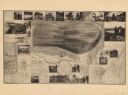
| Description: | This map of Door County, Wisconsin, from the early 20th century shows roads, schools, churches, creameries and cheese factories, orchards, docks, quarries,... |

| Date: | 02 1956 |
|---|---|
| Description: | This 1956 map of Waukesha County, Wisconsin, shows the township and range grid, towns, sections, cities and villages, roads, railroads, dams, airports, par... |

| Date: | 1935 |
|---|---|
| Description: | This 1935 map shows the Wisconsin River from a point approximately 4 miles south of the city of Wisconsin Dells north to Duck Creek in Adams County. Sectio... |

| Date: | 1987 |
|---|---|
| Description: | This 1987 map of Door County, Wisconsin, shows streets and roads, cities and villages, state parks, lakes and streams, and depths in Lake Michigan. A stree... |

| Date: | |
|---|---|
| Description: | View of of Devil's Lake from Inspiration Point. A man is sitting on top of a rock formation in the foreground. |

| Date: | |
|---|---|
| Description: | Elevated view from bluff overlooking the railroad tracks and yard along the Mississippi River. A group of men are gathered on the track near stacks of lumb... |

| Date: | 1929 |
|---|---|
| Description: | View from entrance of a cave looking out to the Mississippi River, a railroad bridge, all surrounded by a forest. There is a small island in the river. |

| Date: | 1929 |
|---|---|
| Description: | Elevated view from Signal Point of the Mississippi River, railroad and surrounding forest and wetlands. |

| Date: | |
|---|---|
| Description: | A bird's eye view overlooking the Mississippi River, sand bars, the railroad bridge, surrounding forests and wetlands. |
| Date: | 1906 |
|---|---|
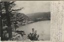
| Description: | View from bluff of Devil's Lake. A road runs along the far shoreline. Caption reads: "Devil's Lake, Baraboo, Wis." |
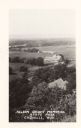
| Date: | |
|---|---|
| Description: | Elevated, photographic postcard view of Nelson Dewey Memorial State Park. There are railroad tracks in the foreground; the Mississippi River is in the back... |
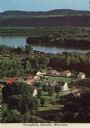
| Date: | |
|---|---|
| Description: | Elevated view of Stonefield Village, with the Mississippi River in the background. Caption reads: "Stonefield, Cassville, Wis." |
If you didn't find the material you searched for, our Library Reference Staff can help.
Call our reference desk at 608-264-6535 or email us at: