 Filter: Categories of Wisconsin Historical Images
Filter: Subject of State parks and reserves
Filter: Subject of water
Filter: Categories of Wisconsin Historical Images
Filter: Subject of State parks and reserves
Filter: Subject of water

| Date: | 1916 |
|---|---|
| Description: | This version of a 1916 Wisconsin Conservation Commission map shows Peninsula State Park in the Town of Gibraltar, Door County, Wisconsin. Depicted are open... |

| Date: | 1990 |
|---|---|
| Description: | This late 20th century tourist map of Sauk County, Wisconsin, shows the highways and roads, cities and towns, parks, airports, canoe landings, hospitals, s... |

| Date: | 1948 |
|---|---|
| Description: | This outline map of Sauk County, Wisconsin, shows the towns, cities and villages, railroads, and streams in the county. |

| Date: | 1949 |
|---|---|
| Description: | This 1949 map shows the topography and significant landmarks in Copper Falls State Park, Ashland County, Wisconsin. |

| Date: | 1990 |
|---|---|
| Description: | This tourism brochure of Ashland County, Wisconsin, from the Ashland Area Chamber of Commerce includes a map of the county showing tourist destinations and... |

| Date: | 1930 |
|---|---|
| Description: | Aerial view looking north across the wooded peninsula separating Europe Bay (top) from Newport Bay. This area is now part of Newport State Park. |

| Date: | 1930 |
|---|---|
| Description: | Aerial view of the northern tip of the Door Peninsula, looking north. Europe Lake is in the center, with Europe Bay to the right. Plum Island and Washingto... |

| Date: | 1930 |
|---|---|
| Description: | Aerial view looking northeast, with Rowley's Bay in the foreground. Europe Lake is to the left, with Europe Bay and Newport Bay separated by a narrow peni... |

| Date: | 1930 |
|---|---|
| Description: | Aerial view over northern Door County, looking northeast across Europe Lake and Europe Bay toward Plum and Washington Islands. Farm fields and orchards con... |

| Date: | 1930 |
|---|---|
| Description: | Aerial view, looking north, across the beach and pier on Europe Bay to Europe Lake and beyond to Washington Island. The land south (to the right) of Europe... |
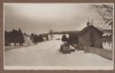
| Date: | 1915 |
|---|---|
| Description: | Winter scene from Egg Harbor Road (Highway 42) in Fish Creek looking north toward frozen Fish Creek Harbor with the bluffs in Peninsula State Park beyond. ... |
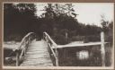
| Date: | 1915 |
|---|---|
| Description: | A rustic foot bridge over Fish Creek connects Peninsula State Park (foreground) with the village of Fish Creek. The Vits house is at the right end of the b... |
| Date: | 1915 |
|---|---|
| Description: | View from the Vits property, looking east, across a rustic foot bridge over Fish Creek leading to Peninsula State Park. A dachshund rests in the middle of ... |

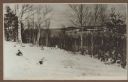
| Date: | 1915 |
|---|---|
| Description: | Elevated view, looking north, from the Hotz family compound near the bluff entrance to Fish Creek. Evergreens and bare birch trees stand in the foreground,... |
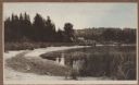
| Date: | 1915 |
|---|---|
| Description: | View looking north over Fish Creek Bay, with Hen Island and Peninsula State Park in the background. There is snow on the ground, and evergreens and bare bi... |

| Date: | 1964 |
|---|---|
| Description: | This 1964 map of Madeline Island, Ashland County, Wisconsin, shows existing and historical locations, roads, the boundaries of a proposed state park, secti... |
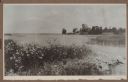
| Date: | 1915 |
|---|---|
| Description: | Wildflowers bloom on the rocky shore of Weborg Point in Peninsula State Park, with Nelson Point in the background. A low pier extends from the point. |
| Date: | 1915 |
|---|---|
| Description: | View of Fish Creek from Weborg's Point in Peninsula State Park. The Fish Creek dock with barnlike warehouse is in center right. Behind the dock is the two-... |

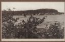
| Date: | 1915 |
|---|---|
| Description: | An unidentified child sits on the rocky shore at Weborg Point. Big Strawberry Island is seen center right, with Chambers Island on the horizon to the left. |

| Date: | 1913 |
|---|---|
| Description: | Two of the photographer's children, Margaret (Sissy), left, and Ferdinand Leonard (Fedy), right, on Weborg Point. Fish Creek Harbor is in the background; t... |
If you didn't find the material you searched for, our Library Reference Staff can help.
Call our reference desk at 608-264-6535 or email us at: