 Filter: Categories of Wisconsin Historical Images
Filter: Subject of State parks and reserves
Filter: Subject of water
Filter: Categories of Wisconsin Historical Images
Filter: Subject of State parks and reserves
Filter: Subject of water

| Date: | 1994 |
|---|---|
| Description: | This brochure consists of a series of 16 maps of the Military Ridge State Park Trail and the Sugar River State Trail. In all, 62 miles of bike trails and 1... |
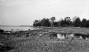
| Date: | 1925 |
|---|---|
| Description: | Rocky shoreline at Nelson Point, now in Peninsula State Park. |

| Date: | 1923 |
|---|---|
| Description: | A small cottage is barely visible through the trees on the rocky shore at Nelson Point, now part of Peninsula State Park. |

| Date: | 1936 |
|---|---|
| Description: | This pictorial tourist map from the Wisconsin Conservation Commission depicts vacation activities and identifies tourist destinations throughout the state.... |

| Date: | 1937 |
|---|---|
| Description: | This map shows the Wisconsin Conservation Department forest protection divisions and the locations of state forests, national forests, Indian reservations,... |

| Date: | 1937 |
|---|---|
| Description: | This Wisconsin Conservation Department map shows the locations of game refuges, fish hatcheries, canning factories, fish camps, and fish refuges in the sta... |

| Date: | 1937 |
|---|---|
| Description: | This Wisconsin Conservation Department map shows the locations of state forests, national forests, county forests, state nurseries, Indian reservations, st... |

| Date: | 05 01 1938 |
|---|---|
| Description: | This map shows the locations of Wisconsin Conservation Department forest protection districts and cooperative areas, state forests, national forests, India... |

| Date: | 1939 |
|---|---|
| Description: | This nine-part map from the U.S. Bureau of Public Roads identifies federal and state highways in Wisconsin by pavement type. County, forest, park, and publ... |

| Date: | 1944 |
|---|---|
| Description: | This nine-part map from the U.S. Bureau of Public Roads identifies federal and state highways in Wisconsin by pavement type. County, forest, park, and publ... |

| Date: | 1950 |
|---|---|
| Description: | This road map shows federal, state and county roads in Wisconsin, northern Illinois, northeastern Iowa, eastern Minnesota, and the western portion of Michi... |

| Date: | 1920 |
|---|---|
| Description: | View from shoreline of a water slide at Mirror Lake State Park. A woman rides down the slide into the lake, and a few people stand on the platform behind h... |
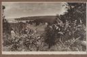
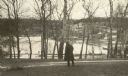
| Date: | 1920 |
|---|---|
| Description: | A well-dressed man identified as Uncle Rudolph Schenck takes in the view from a bluff overlooking the Fish Creek valley and harbor. There are houses and ou... |
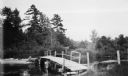
| Date: | 1912 |
|---|---|
| Description: | A footbridge crossing Fish Creek into Peninsula Stat Park. |

| Date: | |
|---|---|
| Description: | A map of Grant County, Wisconsin showing the locations of townships, towns, cities, villages, roads, railroads, schools, cemeteries, churches, rivers, and ... |
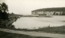
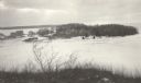
| Date: | 1920 |
|---|---|
| Description: | Several boats are moored in the protected harbor. An old warehouse stands on a pier. A tall bluff and rock cliff dominates the opposite shoreline. |
| Date: | 02 1925 |
|---|---|
| Description: | There is smoke damage to the bricks evident above the windows of the company store in this view of the ghost town of Fayette. To the right, with dormers, i... |
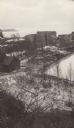
| Date: | 02 1925 |
|---|---|
| Description: | An unidentified man looks across Snail Shell Harbor at the remains of the Jackson Iron Company works. The large furnace complex is visible through the tree... |
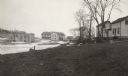
| Date: | 02 1925 |
|---|---|
| Description: | Elevated view of the abandoned town of Fayette. Snail Shell Harbor is in the foreground, with a low warehouse along the boat dock and empty buildings on th... |
| Date: | 02 1925 |
|---|---|
| Description: | Elevated view of the abandoned Jackson Iron Company furnace complex at Fayette, on the shore of Snail Shell Harbor. Lake Michigan is in the background. |
If you didn't find the material you searched for, our Library Reference Staff can help.
Call our reference desk at 608-264-6535 or email us at: