 Filter: Categories of Wisconsin Historical Images
Filter: Subject of State parks and reserves
Filter: Subject of water
Filter: Categories of Wisconsin Historical Images
Filter: Subject of State parks and reserves
Filter: Subject of water

| Date: | 08 11 1906 |
|---|---|
| Description: | Black and white postcard of the rock formation called the Devil's Doorway in Devil's Lake State Park. Graffiti is visible on the formation. The lake, bluff... |

| Date: | |
|---|---|
| Description: | Black and white postcard of the boat landing in front of Cliff House, a resort hotel, in Devil's Lake State Park. Two men show off their catch of seven fis... |
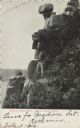
| Date: | 07 13 1906 |
|---|---|
| Description: | Black and white photographic postcard of the rock formation called the Great Stone Face in Devil's Lake State Park. A man is standing to the right of the "... |
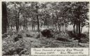
| Date: | |
|---|---|
| Description: | Photographic postcard of picnic grounds at a spring in Blue Mounds State Park. The spring is running out of a brick catch basin on the right. A woman weari... |
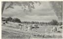
| Date: | |
|---|---|
| Description: | Photographic postcard view of the swimming pool on top of the mounds in Blue Mounds State Park. There are people swimming as well as standing around the si... |

| Date: | 1935 |
|---|---|
| Description: | View of Bad River rushing over cliff at Copper Falls State Park. |
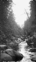
| Date: | 1935 |
|---|---|
| Description: | The Bad River flowing through boulders and a gorge. |
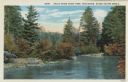
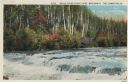
| Date: | 1913 |
|---|---|
| Description: | Colorized postcard view of the Brule River flowing through the forest. Some trees show autumn color. Caption reads: "Brule River State Park, Wisconsin. Sce... |
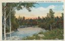
| Date: | 1913 |
|---|---|
| Description: | Colorized postcard view of the Brule River flowing through the forest. Some trees show autumn color. Caption reads: "Brule River State Park, Wisconsin. On ... |
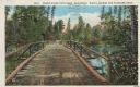
| Date: | 1913 |
|---|---|
| Description: | Colorized postcard of a wooden bridge over the Brule River flowing through the forest. A person is on the far side of the bridge. Caption reads: "Brule Riv... |
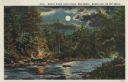
| Date: | 1913 |
|---|---|
| Description: | Colorized postcard view of the Brule River flowing through the forest by moonlight. Some trees show autumn color. There is a campfire on the shore with thr... |
| Date: | 1913 |
|---|---|
| Description: | Colorized postcard view of the Lower Falls on the Brule River flowing through the forest. Some trees are showing autumn color. Caption reads: "Brule River ... |
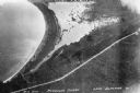
| Date: | 1934 |
|---|---|
| Description: | Aerial view of Big Bay on Madeline Island. This area later became Big Bay State Park. |

| Date: | 1981 |
|---|---|
| Description: | Plat map of Madeline Island surrounded by Basswood, Michigan and Gull Islands. |

| Date: | |
|---|---|
| Description: | Elevated view of Devil's Lake and surrounding area from a bluff on the east side of the lake. A man is standing on top of the rock formation near the cente... |

| Date: | 09 24 1910 |
|---|---|
| Description: | View of several fisherman's homes on Bear Island, one of the islands that make up the Apostle Islands. An American flag is flying between buildings and a d... |

| Date: | |
|---|---|
| Description: | View looking out at beach scene at Devil's Lake. There are benches on the shore where vacationers observe the swimmers. Two wooden structures have ladders ... |
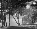
| Date: | 1922 |
|---|---|
| Description: | View of Devil's Lake from the shore of the Kirkland Hotel, located at the southeast corner of the lake. There is building, perhaps a boathouse, on the shor... |

| Date: | |
|---|---|
| Description: | Elevated view of Devil's Doorway rock formation. Far below is Devil's Lake and the opposite shoreline with bluffs in the distance. |

| Date: | 1968 |
|---|---|
| Description: | The map shows fire towers, public camp grounds, roads, snow mobile & riding trails, trout lakes, foot trails, railroads, and National Forest boundaries. |
If you didn't find the material you searched for, our Library Reference Staff can help.
Call our reference desk at 608-264-6535 or email us at: