 Filter: Categories of Wisconsin Historical Images
Filter: Subject of State parks and reserves
Filter: Subject of water
Filter: Year of 1900-1999
Filter: Categories of Wisconsin Historical Images
Filter: Subject of State parks and reserves
Filter: Subject of water
Filter: Year of 1900-1999
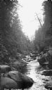
| Date: | 1935 |
|---|---|
| Description: | The Bad River flowing through boulders and a gorge. |
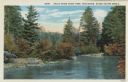
| Date: | 1913 |
|---|---|
| Description: | Colorized postcard view of the Brule River flowing through the forest. Some trees show autumn color. Caption reads: "Brule River State Park, Wisconsin. Sce... |
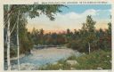
| Date: | 1913 |
|---|---|
| Description: | Colorized postcard view of the Brule River flowing through the forest. Some trees show autumn color. Caption reads: "Brule River State Park, Wisconsin. On ... |
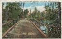
| Date: | 1913 |
|---|---|
| Description: | Colorized postcard of a wooden bridge over the Brule River flowing through the forest. A person is on the far side of the bridge. Caption reads: "Brule Riv... |
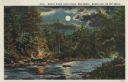
| Date: | 1913 |
|---|---|
| Description: | Colorized postcard view of the Brule River flowing through the forest by moonlight. Some trees show autumn color. There is a campfire on the shore with thr... |
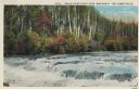
| Date: | 1913 |
|---|---|
| Description: | Colorized postcard view of the Lower Falls on the Brule River flowing through the forest. Some trees are showing autumn color. Caption reads: "Brule River ... |
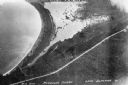
| Date: | 1934 |
|---|---|
| Description: | Aerial view of Big Bay on Madeline Island. This area later became Big Bay State Park. |

| Date: | 1981 |
|---|---|
| Description: | Plat map of Madeline Island surrounded by Basswood, Michigan and Gull Islands. |

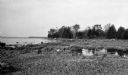
| Date: | 09 24 1910 |
|---|---|
| Description: | View of several fisherman's homes on Bear Island, one of the islands that make up the Apostle Islands. An American flag is flying between buildings and a d... |
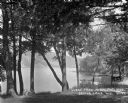
| Date: | 1922 |
|---|---|
| Description: | View of Devil's Lake from the shore of the Kirkland Hotel, located at the southeast corner of the lake. There is building, perhaps a boathouse, on the shor... |

| Date: | 1968 |
|---|---|
| Description: | The map shows fire towers, public camp grounds, roads, snow mobile & riding trails, trout lakes, foot trails, railroads, and National Forest boundaries. |

| Date: | 1994 |
|---|---|
| Description: | This brochure consists of a series of 16 maps of the Military Ridge State Park Trail and the Sugar River State Trail. In all, 62 miles of bike trails and 1... |
| Date: | 1925 |
|---|---|
| Description: | Rocky shoreline at Nelson Point, now in Peninsula State Park. |

| Date: | 1923 |
|---|---|
| Description: | A small cottage is barely visible through the trees on the rocky shore at Nelson Point, now part of Peninsula State Park. |

| Date: | 1936 |
|---|---|
| Description: | This pictorial tourist map from the Wisconsin Conservation Commission depicts vacation activities and identifies tourist destinations throughout the state.... |

| Date: | 1937 |
|---|---|
| Description: | This map shows the Wisconsin Conservation Department forest protection divisions and the locations of state forests, national forests, Indian reservations,... |

| Date: | 1937 |
|---|---|
| Description: | This Wisconsin Conservation Department map shows the locations of game refuges, fish hatcheries, canning factories, fish camps, and fish refuges in the sta... |

| Date: | 1937 |
|---|---|
| Description: | This Wisconsin Conservation Department map shows the locations of state forests, national forests, county forests, state nurseries, Indian reservations, st... |

| Date: | 05 01 1938 |
|---|---|
| Description: | This map shows the locations of Wisconsin Conservation Department forest protection districts and cooperative areas, state forests, national forests, India... |

| Date: | 1939 |
|---|---|
| Description: | This nine-part map from the U.S. Bureau of Public Roads identifies federal and state highways in Wisconsin by pavement type. County, forest, park, and publ... |
If you didn't find the material you searched for, our Library Reference Staff can help.
Call our reference desk at 608-264-6535 or email us at: