 Filter: Categories of Wisconsin Historical Images
Filter: Subject of State parks and reserves
Filter: Subject of water
Filter: Subject of service industries
Filter: Categories of Wisconsin Historical Images
Filter: Subject of State parks and reserves
Filter: Subject of water
Filter: Subject of service industries
| Date: | 1878 |
|---|---|
| Description: | Courtyard at Cliff House, a resort hotel built shortly after 1872 when Devil's Lake was reached by rail. The house has a stone first floor, a balcony on ea... |
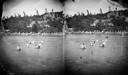
| Date: | 1878 |
|---|---|
| Description: | Swimming in the lake with the Cliff House in background. Cliff House was a resort hotel built shortly after 1872, when Devil's Lake was reached by rail. Bo... |
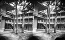
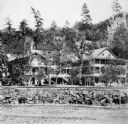
| Date: | 1878 |
|---|---|
| Description: | Cliff House, a resort hotel built shortly after 1872 when Devil's Lake was reached by rail. Three-story frame house with balcony on each floor. There is a ... |
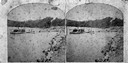
| Date: | 1874 |
|---|---|
| Description: | View west from the Cliff House at Devil's Lake. |

| Date: | 1954 |
|---|---|
| Description: | View looking west from Eagle Bluff toward Nicolet Bay, the Strawberry Islands, and Chambers Island. Three people are sitting on the stone wall of the overl... |

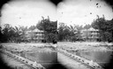
| Date: | |
|---|---|
| Description: | View of the Cliff House, a resort near Devil's Lake. Caption on stereograph reads: "Devil's Lake and Vicinity. Views of the Cliff House, from the beach." |
| Date: | 1925 |
|---|---|
| Description: | A copy of an original photograph by H.H. Bennett of the Cliff House Inn at Devil's Lake as seen from the beach. Abraham Lincoln is reported to have slept h... |
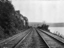
| Date: | |
|---|---|
| Description: | View of Chicago, Northwestern Railroad set of two railroad tracks at Devil's Lake, chartered in 1859. To the right, power lines run the length of the Devil... |

| Date: | 1952 |
|---|---|
| Description: | The famous Dells of the Wisconsin River. A souvenir map embellished with bits of history and points of interest. |

| Date: | |
|---|---|
| Description: | View looking out at beach scene at Devil's Lake. There are benches on the shore where vacationers observe the swimmers. Two wooden structures have ladders ... |

| Date: | 1968 |
|---|---|
| Description: | The map shows fire towers, public camp grounds, roads, snow mobile & riding trails, trout lakes, foot trails, railroads, and National Forest boundaries. |

| Date: | 1936 |
|---|---|
| Description: | This pictorial tourist map from the Wisconsin Conservation Commission depicts vacation activities and identifies tourist destinations throughout the state.... |

| Date: | 1937 |
|---|---|
| Description: | This map shows the Wisconsin Conservation Department forest protection divisions and the locations of state forests, national forests, Indian reservations,... |

| Date: | 05 01 1938 |
|---|---|
| Description: | This map shows the locations of Wisconsin Conservation Department forest protection districts and cooperative areas, state forests, national forests, India... |

| Date: | 1950 |
|---|---|
| Description: | This road map shows federal, state and county roads in Wisconsin, northern Illinois, northeastern Iowa, eastern Minnesota, and the western portion of Michi... |
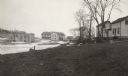
| Date: | 02 1925 |
|---|---|
| Description: | There is smoke damage to the bricks evident above the windows of the company store in this view of the ghost town of Fayette. To the right, with dormers, i... |
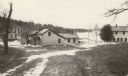
| Date: | 02 1925 |
|---|---|
| Description: | Abandoned workers' houses stand along the shore of Lake Michigan. The Fayette Tourists Lodge is on the far left. |

| Date: | 1990 |
|---|---|
| Description: | This tourism brochure of Ashland County, Wisconsin, from the Ashland Area Chamber of Commerce includes a map of the county showing tourist destinations and... |
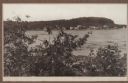
| Date: | 1915 |
|---|---|
| Description: | View of Fish Creek from Weborg's Point in Peninsula State Park. The Fish Creek dock with barnlike warehouse is in center right. Behind the dock is the two-... |

| Date: | 1991 |
|---|---|
| Description: | This 1991 map of Burnett County, Wisconsin, shows Governor Knowles State Forest, wildlife areas, public hunting grounds, and other outdoor recreation facil... |
If you didn't find the material you searched for, our Library Reference Staff can help.
Call our reference desk at 608-264-6535 or email us at: