 Filter: Categories of Wisconsin Historical Images
Filter: Subject of State parks and reserves
Filter: Subject of water
Filter: Subject of persons
Filter: Categories of Wisconsin Historical Images
Filter: Subject of State parks and reserves
Filter: Subject of water
Filter: Subject of persons

| Date: | |
|---|---|
| Description: | View from shoreline at Devil's Lake of a boy standing in the shallow water leaning against a sailboat. A young girl wearing a hat is sitting on the sandy b... |

| Date: | |
|---|---|
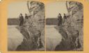
| Description: | Two men climbing Cleft Rock on East Bluff. Devil's Lake is in the background. Text at right: "Wanderings Among the Wonders and Beauties of Wisconsin Scener... |
| Date: | |
|---|---|
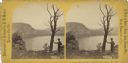
| Description: | View of a man leaning on a tree overlooking Devil's Lake. Text at right reads: "A Visit to Devil's Lake, Sauk County, Wis., in the Summer of 1870." |
| Date: | 03 22 1889 |
|---|---|
| Description: | Evaline Helen Marshall and unidentified woman on a rock cliff over Devil's Lake. |

| Date: | 1990 |
|---|---|
| Description: | This tourism brochure of Ashland County, Wisconsin, from the Ashland Area Chamber of Commerce includes a map of the county showing tourist destinations and... |
| Date: | 1915 |
|---|---|
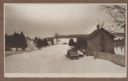
| Description: | Winter scene from Egg Harbor Road (Highway 42) in Fish Creek looking north toward frozen Fish Creek Harbor with the bluffs in Peninsula State Park beyond. ... |
| Date: | 1915 |
|---|---|
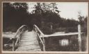
| Description: | A rustic foot bridge over Fish Creek connects Peninsula State Park (foreground) with the village of Fish Creek. The Vits house is at the right end of the b... |
| Date: | 1915 |
|---|---|
| Description: | View from the Vits property, looking east, across a rustic foot bridge over Fish Creek leading to Peninsula State Park. A dachshund rests in the middle of ... |

| Date: | 1915 |
|---|---|
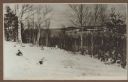
| Description: | Elevated view, looking north, from the Hotz family compound near the bluff entrance to Fish Creek. Evergreens and bare birch trees stand in the foreground,... |
| Date: | 1915 |
|---|---|
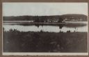
| Description: | View looking north over Fish Creek Bay, with Hen Island and Peninsula State Park in the background. There is snow on the ground, and evergreens and bare bi... |
| Date: | 1915 |
|---|---|
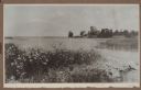
| Description: | Wildflowers bloom on the rocky shore of Weborg Point in Peninsula State Park, with Nelson Point in the background. A low pier extends from the point. |
| Date: | 1915 |
|---|---|
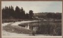
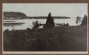
| Description: | View of Fish Creek from Weborg's Point in Peninsula State Park. The Fish Creek dock with barnlike warehouse is in center right. Behind the dock is the two-... |

| Date: | 1915 |
|---|---|
| Description: | An unidentified child sits on the rocky shore at Weborg Point. Big Strawberry Island is seen center right, with Chambers Island on the horizon to the left. |

| Date: | 1913 |
|---|---|
| Description: | Two of the photographer's children, Margaret (Sissy), left, and Ferdinand Leonard (Fedy), right, on Weborg Point. Fish Creek Harbor is in the background; t... |

| Date: | 1915 |
|---|---|
| Description: | Elevated view over a heavily wooded area to Fish Creek Harbor and Hen Island, with Peninsula State Park in the background. |

| Date: | 1915 |
|---|---|
| Description: | Birch and evergreen trees line the rocky shore of Toft Point, with Cana Island and its lighthouse in the background. |

| Date: | 1991 |
|---|---|
| Description: | This 1991 map of Burnett County, Wisconsin, shows Governor Knowles State Forest, wildlife areas, public hunting grounds, and other outdoor recreation facil... |
| Date: | 1915 |
|---|---|
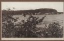
| Description: | Hen Island is reflected in the water of Fish Creek Bay in this view from Nelson Point in Peninsula State Park. The homes and businesses of Fish Creek are i... |
| Date: | 1915 |
|---|---|
| Description: | View down hill towards a man fishing from the pier at Nelson Point in Peninsula State Park. Fish Creek is seen across the bay. Dr. Welcker's Casino is the ... |
| Date: | 1893 |
|---|---|
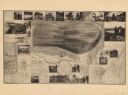
| Description: | A bird’s-eye view map. Inset maps read: Honey Creek Basin and Baraboo Bluffs -- Sauk County -- The ancient Green Bay glacier. Includes distant chart, eleva... |
If you didn't find the material you searched for, our Library Reference Staff can help.
Call our reference desk at 608-264-6535 or email us at: