 Filter: Categories of Wisconsin Historical Images
Filter: Subject of State parks and reserves
Filter: Subject of water
Filter: Subject of land use
Filter: Categories of Wisconsin Historical Images
Filter: Subject of State parks and reserves
Filter: Subject of water
Filter: Subject of land use
| Date: | |
|---|---|
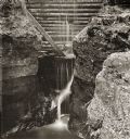
| Description: | Elevated view of dam at Pewit's Nest on Skillet Creek. |
| Date: | 1877 |
|---|---|
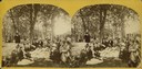
| Description: | Well-dressed young couples sit in the foreground. In the background is a picket fence running along a busy road with horse and buggy traffic. Further on is... |
| Date: | 1877 |
|---|---|
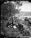
| Description: | "The Grand Regatta, at Devil's Lake, June 21st & 22nd, 1877." A crowd sits on the ground about to commence lunch at Devil's Lake. |
| Date: | 1945 |
|---|---|
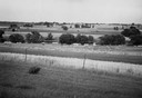
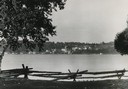
| Description: | Field prior to the park's reconstruction, with a fence in the foreground. A river is at the bottom of the hill. |
| Date: | 1950 |
|---|---|
| Description: | Downtown Ephraim from Peninsula State Park, directly across the bay. |
| Date: | 1940 |
|---|---|
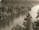
| Description: | Elevated view of a canoe on the St. Croix River with wooded areas on both sides within the Interstate State Park. Established in 1900, Interstate Park was... |
| Date: | 1963 |
|---|---|
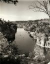
| Description: | Elevated view of the Dalles on the Saint Croix River with boats docked and crossing. |

| Date: | 1947 |
|---|---|
| Description: | The Passenger Pigeon Monument was designed and built around 1947. It was erected by the Wisconsin Society for Ornithology. |

| Date: | 1960 |
|---|---|
| Description: | View of Ennis Lake, also known as Fountain Lake, located in the John Muir Memorial Park near Montello. As a boy, John Muir lived with his family on the sho... |

| Date: | 1960 |
|---|---|
| Description: | View of Ennis Lake, also known as Fountain Lake, located in the John Muir Memorial Park near Montello. As a boy, John Muir lived with his family on the sho... |

| Date: | 1939 |
|---|---|
| Description: | A color, pictorial map. Scale: 10 miles to the inch. Shows state parks and forests, proposed state parkways, proposed state monuments and memorials, nation... |
| Date: | |
|---|---|
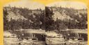
| Description: | Two men and a woman attend to boats in the lake, while three children wait ashore. |

| Date: | 1906 |
|---|---|
| Description: | Four men, identified as Charles E. Brown of Milwaukee, Joyce W. Caron, H.E. Cole (second from right), and A.B. Stout, all of Baraboo, rest at Messenger's S... |
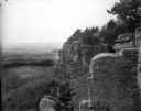
| Date: | 1909 |
|---|---|
| Description: | Side view of a woman sitting on a rock ledge on the face of Gibraltar Rock bluff. Hills, fields and the Wisconsin River are visible far below in the backgr... |

| Date: | |
|---|---|
| Description: | Stereograph of a man sitting at Devil's Elbow. Text at right: "Wanderings Among the Wonders and Beauties of Wisconsin Scenery." |

| Date: | 1920 |
|---|---|
| Description: | A map of the Nelson-Dewey State Park at the confluence of the Mississippi and Wisconsin rivers, showing the topographical features of the area, as well as ... |

| Date: | 1920 |
|---|---|
| Description: | This 1920 map actually depicts present-day Wyalusing State Park at the confluence of the Mississippi and Wisconsin rivers in the Town of Wyalusing, Grant C... |

| Date: | 1916 |
|---|---|
| Description: | This Wisconsin Conservation Commission map from 1916 shows Peninsula State Park in the Town of Gibraltar, Door County, Wisconsin. Depicted are open and pla... |

| Date: | 1916 |
|---|---|
| Description: | This version of a 1916 Wisconsin Conservation Commission map shows Peninsula State Park in the Town of Gibraltar, Door County, Wisconsin. Depicted are open... |

| Date: | 1930 |
|---|---|
| Description: | Aerial view of the northern tip of the Door Peninsula, looking north. Europe Lake is in the center, with Europe Bay to the right. Plum Island and Washingto... |
If you didn't find the material you searched for, our Library Reference Staff can help.
Call our reference desk at 608-264-6535 or email us at: