 Filter: Categories of Wisconsin Historical Images
Filter: Subject of State parks and reserves
Filter: Subject of water
Filter: Subject of land
Filter: Categories of Wisconsin Historical Images
Filter: Subject of State parks and reserves
Filter: Subject of water
Filter: Subject of land
| Date: | |
|---|---|
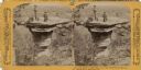
| Description: | Three hunters and their dog posing on the top of Stand Rock. Text at right: "Wanderings Among the Wonders and Beauties of Wisconsin Scenery." |

| Date: | 06 24 1878 |
|---|---|
| Description: | Stereograph of three men at the top of Stand Rock. One man is standing holding his rifle, while the two other people are sitting. Text at right: "Wandering... |

| Date: | |
|---|---|
| Description: | Stereograph of H.H. Bennett manning his camera on shore near Steamboat Rock. A woman is in a canoe near the shoreline, and a man is reading a book on the f... |

| Date: | 1903 |
|---|---|
| Description: | Two men canoeing at Steamboat Rock. Text at right: "Wanderings Among the Wonders and Beauties of Wisconsin Scenery." |
| Date: | |
|---|---|
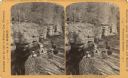
| Description: | Elevated view of two men sitting on the side of a rock formation. The man on the right is holding a rifle and a stringer of squirrels. The man on the left ... |

| Date: | |
|---|---|
| Description: | Stereograph of a man sitting at Devil's Elbow. Text at right: "Wanderings Among the Wonders and Beauties of Wisconsin Scenery." |

| Date: | |
|---|---|
| Description: | View from above of two girls holding hands on a cliff overlooking Mirror Lake. Text at right: "Wanderings Among the Wonders and Beauties of Wisconsin Scene... |

| Date: | |
|---|---|
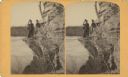
| Description: | Two men climbing Cleft Rock on East Bluff. Devil's Lake is in the background. Text at right: "Wanderings Among the Wonders and Beauties of Wisconsin Scener... |
| Date: | |
|---|---|
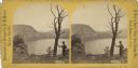
| Description: | View of a man leaning on a tree overlooking Devil's Lake. Text at right reads: "A Visit to Devil's Lake, Sauk County, Wis., in the Summer of 1870." |
| Date: | 03 22 1889 |
|---|---|
| Description: | Evaline Helen Marshall and unidentified woman on a rock cliff over Devil's Lake. |

| Date: | 1920 |
|---|---|
| Description: | A map of the Nelson-Dewey State Park at the confluence of the Mississippi and Wisconsin rivers, showing the topographical features of the area, as well as ... |

| Date: | 1920 |
|---|---|
| Description: | This 1920 map actually depicts present-day Wyalusing State Park at the confluence of the Mississippi and Wisconsin rivers in the Town of Wyalusing, Grant C... |

| Date: | 1920 |
|---|---|
| Description: | This early 1920s map shows state-owned land in townships 38 and 39, range 7 east, the towns of Lake Tomahawk and Woodruff, in Oneida County, Wisconsin, tha... |

| Date: | 1916 |
|---|---|
| Description: | This Wisconsin Conservation Commission map from 1916 shows Peninsula State Park in the Town of Gibraltar, Door County, Wisconsin. Depicted are open and pla... |

| Date: | 1916 |
|---|---|
| Description: | This version of a 1916 Wisconsin Conservation Commission map shows Peninsula State Park in the Town of Gibraltar, Door County, Wisconsin. Depicted are open... |

| Date: | 1990 |
|---|---|
| Description: | This late 20th century tourist map of Sauk County, Wisconsin, shows the highways and roads, cities and towns, parks, airports, canoe landings, hospitals, s... |

| Date: | 1948 |
|---|---|
| Description: | This outline map of Sauk County, Wisconsin, shows the towns, cities and villages, railroads, and streams in the county. |

| Date: | 1949 |
|---|---|
| Description: | This 1949 map shows the topography and significant landmarks in Copper Falls State Park, Ashland County, Wisconsin. |

| Date: | 1990 |
|---|---|
| Description: | This tourism brochure of Ashland County, Wisconsin, from the Ashland Area Chamber of Commerce includes a map of the county showing tourist destinations and... |
If you didn't find the material you searched for, our Library Reference Staff can help.
Call our reference desk at 608-264-6535 or email us at:
