 Filter: Categories of Wisconsin Historical Images
Filter: Subject of State parks and reserves
Filter: Subject of water
Filter: Subject of forests and forestry
Filter: Categories of Wisconsin Historical Images
Filter: Subject of State parks and reserves
Filter: Subject of water
Filter: Subject of forests and forestry
| Date: | |
|---|---|
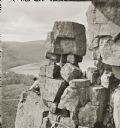
| Description: | Devil's Lake vicinity; Boulders on top of cliff, at foot of Devil's Doorway; man on the left. |
| Date: | 1948 |
|---|---|
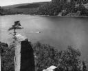
| Description: | View from the east bluff of lake with a motorboat. A geologic pinnacle juts out from the lower left of the image. |
| Date: | 1940 |
|---|---|
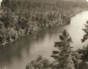
| Description: | Elevated view of a canoe on the St. Croix River with wooded areas on both sides within the Interstate State Park. Established in 1900, Interstate Park was... |

| Date: | 1939 |
|---|---|
| Description: | A color, pictorial map. Scale: 10 miles to the inch. Shows state parks and forests, proposed state parkways, proposed state monuments and memorials, nation... |

| Date: | |
|---|---|
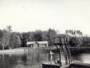
| Description: | View from shoreline of boats docked at the fishing wharf. People are fishing from the pier, and a group of people are in a rowboat near a ferry. There are ... |
| Date: | 07 1940 |
|---|---|
| Description: | The bathing beach and bath house at Copper Falls State Park. Two swimmers are sitting and standing on a dock with a platform. |
| Date: | |
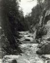
|---|---|
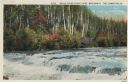
| Description: | View up the Bad River Gorge below Copper Falls at Copper Falls State Park. |
| Date: | 1940 |
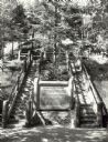
|---|---|
| Description: | Two rustic stairways leading down to the Bad River at Copper Falls State Park. At the bottom of the stairs is a sign telling the geological story of Copper... |
| Date: | 09 1937 |
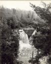
|---|---|
| Description: | Elevated view of Copper Falls at Copper Falls State Park. |
| Date: | 09 1937 |
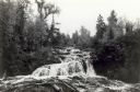
|---|---|
| Description: | View upriver of the rapids above Tyler Falls at Copper Falls State Park. In the distance you can see a bridge across the river. |

| Date: | 07 1940 |
|---|---|
| Description: | Two boys and two girls swimming at the Bad River at Copper Falls State Park. One of the girls is diving off the dock that also has a platform. In the backg... |
| Date: | |
|---|---|
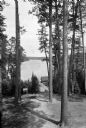
| Description: | View through a wooded area toward the lake in Itasca State Park. A cabin stands near the shoreline. |
| Date: | 1852 |
|---|---|
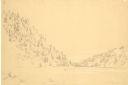
| Description: | Devil's Lake from shore flanked by steep tree-covered hillsides. A small solitary rowboat floats near the distant shore. |
| Date: | 1913 |
|---|---|
| Description: | Colorized postcard view of the Lower Falls on the Brule River flowing through the forest. Some trees are showing autumn color. Caption reads: "Brule River ... |

| Date: | 05 01 1938 |
|---|---|
| Description: | This map shows the locations of Wisconsin Conservation Department forest protection districts and cooperative areas, state forests, national forests, India... |

| Date: | 1939 |
|---|---|
| Description: | This nine-part map from the U.S. Bureau of Public Roads identifies federal and state highways in Wisconsin by pavement type. County, forest, park, and publ... |

| Date: | 1944 |
|---|---|
| Description: | This nine-part map from the U.S. Bureau of Public Roads identifies federal and state highways in Wisconsin by pavement type. County, forest, park, and publ... |

| Date: | |
|---|---|
| Description: | Two men climbing Cleft Rock on East Bluff. Devil's Lake is in the background. Text at right: "Wanderings Among the Wonders and Beauties of Wisconsin Scener... |

| Date: | 1920 |
|---|---|
| Description: | This early 1920s map shows state-owned land in townships 38 and 39, range 7 east, the towns of Lake Tomahawk and Woodruff, in Oneida County, Wisconsin, tha... |

| Date: | 1930 |
|---|---|
| Description: | Aerial view looking north across the wooded peninsula separating Europe Bay (top) from Newport Bay. This area is now part of Newport State Park. |
If you didn't find the material you searched for, our Library Reference Staff can help.
Call our reference desk at 608-264-6535 or email us at: