 Filter: Categories of Wisconsin Historical Images
Filter: Subject of State parks and reserves
Filter: Subject of water
Filter: County of Ashland
Filter: Categories of Wisconsin Historical Images
Filter: Subject of State parks and reserves
Filter: Subject of water
Filter: County of Ashland
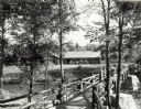
| Date: | 1940 |
|---|---|
| Description: | People on a rustic bridge over river at Copper Falls State Park. A long log building is in the background on the other side of the river. |
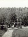
| Date: | |
|---|---|
| Description: | Two people on a rustic bridge over Bad River at Copper Falls State Park. |
| Date: | 1935 |
|---|---|
| Description: | View from rocky shoreline towards the Brownstone Falls in Copper Falls State Park. |
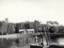
| Date: | 07 1940 |
|---|---|
| Description: | The bathing beach and bath house at Copper Falls State Park. Two swimmers are sitting and standing on a dock with a platform. |
| Date: | |
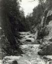
|---|---|
| Description: | View up the Bad River Gorge below Copper Falls at Copper Falls State Park. |
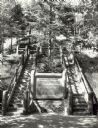
| Date: | 1940 |
|---|---|
| Description: | Two rustic stairways leading down to the Bad River at Copper Falls State Park. At the bottom of the stairs is a sign telling the geological story of Copper... |
| Date: | 09 1937 |
|---|---|
| Description: | Elevated view of Copper Falls at Copper Falls State Park. |
| Date: | 09 1937 |
|---|---|
| Description: | View upriver of the rapids above Tyler Falls at Copper Falls State Park. In the distance you can see a bridge across the river. |

| Date: | 07 1940 |
|---|---|
| Description: | Two boys and two girls swimming at the Bad River at Copper Falls State Park. One of the girls is diving off the dock that also has a platform. In the backg... |

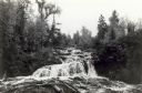
| Date: | 1935 |
|---|---|
| Description: | View of Bad River rushing over cliff at Copper Falls State Park. |
| Date: | 1935 |
|---|---|
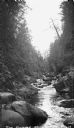
| Description: | The Bad River flowing through boulders and a gorge. |
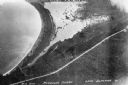
| Date: | 1934 |
|---|---|
| Description: | Aerial view of Big Bay on Madeline Island. This area later became Big Bay State Park. |

| Date: | 1981 |
|---|---|
| Description: | Plat map of Madeline Island surrounded by Basswood, Michigan and Gull Islands. |

| Date: | 09 24 1910 |
|---|---|
| Description: | View of several fisherman's homes on Bear Island, one of the islands that make up the Apostle Islands. An American flag is flying between buildings and a d... |

| Date: | 1949 |
|---|---|
| Description: | This 1949 map shows the topography and significant landmarks in Copper Falls State Park, Ashland County, Wisconsin. |

| Date: | 1990 |
|---|---|
| Description: | This tourism brochure of Ashland County, Wisconsin, from the Ashland Area Chamber of Commerce includes a map of the county showing tourist destinations and... |

| Date: | 1964 |
|---|---|
| Description: | This 1964 map of Madeline Island, Ashland County, Wisconsin, shows existing and historical locations, roads, the boundaries of a proposed state park, secti... |
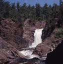
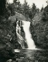
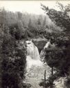
| Date: | |
|---|---|
| Description: | View of Brownstone Falls on Bad River. Rock formations are on the left and right banks. Trees are along the top of the rock formations. |
If you didn't find the material you searched for, our Library Reference Staff can help.
Call our reference desk at 608-264-6535 or email us at:

