 Filter: Categories of Wisconsin Historical Images
Filter: Subject of State parks and reserves
Filter: Subject of water
Filter: Creator Name of Unknown
Filter: County of Ashland
Filter: Categories of Wisconsin Historical Images
Filter: Subject of State parks and reserves
Filter: Subject of water
Filter: Creator Name of Unknown
Filter: County of Ashland
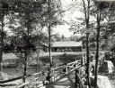
| Date: | 1940 |
|---|---|
| Description: | People on a rustic bridge over river at Copper Falls State Park. A long log building is in the background on the other side of the river. |
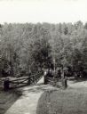
| Date: | |
|---|---|
| Description: | Two people on a rustic bridge over Bad River at Copper Falls State Park. |
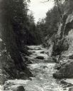
| Date: | |
|---|---|
| Description: | View up the Bad River Gorge below Copper Falls at Copper Falls State Park. |
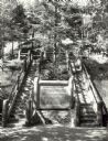
| Date: | 1940 |
|---|---|
| Description: | Two rustic stairways leading down to the Bad River at Copper Falls State Park. At the bottom of the stairs is a sign telling the geological story of Copper... |

| Date: | 1981 |
|---|---|
| Description: | Plat map of Madeline Island surrounded by Basswood, Michigan and Gull Islands. |

| Date: | 1949 |
|---|---|
| Description: | This 1949 map shows the topography and significant landmarks in Copper Falls State Park, Ashland County, Wisconsin. |
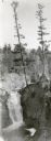
| Date: | 1930 |
|---|---|
| Description: | An elevated view of Brownstone Falls. Two tall pines are growing at the top edge of a rock to the right of the falls. |
If you didn't find the material you searched for, our Library Reference Staff can help.
Call our reference desk at 608-264-6535 or email us at:
