 Filter: Categories of Wisconsin Historical Images
Filter: Subject of State parks and reserves
Filter: Subject of tourism
Filter: Categories of Wisconsin Historical Images
Filter: Subject of State parks and reserves
Filter: Subject of tourism

| Date: | 1954 |
|---|---|
| Description: | View looking west from Eagle Bluff toward Nicolet Bay, the Strawberry Islands, and Chambers Island. Three people are sitting on the stone wall of the overl... |
| Date: | |
|---|---|
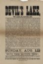
| Description: | Advertisement for a train trip to Devil's Lake. The trip originates in Elgin, Illinios, with pick-ups in East Elgin, Dundee, Carpenterville and Algonquin. ... |

| Date: | 1952 |
|---|---|
| Description: | The famous Dells of the Wisconsin River. A souvenir map embellished with bits of history and points of interest. |
| Date: | 1930 |
|---|---|
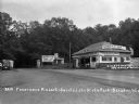
| Description: | View of the entrance to Devil's Lake State Park. There is an information center offering gas, food, and Blatz beer. Two storekeepers and a boy sit on the p... |
| Date: | 1925 |
|---|---|
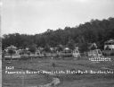
| Description: | View of two-seat lawn swings amid trees on a lawn. Cabins are along a hill in the background. There is an information center on the far left. |

| Date: | |
|---|---|
| Description: | View looking out at beach scene at Devil's Lake. There are benches on the shore where vacationers observe the swimmers. Two wooden structures have ladders ... |

| Date: | 1936 |
|---|---|
| Description: | This pictorial tourist map from the Wisconsin Conservation Commission depicts vacation activities and identifies tourist destinations throughout the state.... |

| Date: | 1950 |
|---|---|
| Description: | This road map shows federal, state and county roads in Wisconsin, northern Illinois, northeastern Iowa, eastern Minnesota, and the western portion of Michi... |

| Date: | 1975 |
|---|---|
| Description: | A tourist map of Grant County that displays the various activities and attractions found in the cities throughout the county, such as boat landings, fishin... |

| Date: | 1990 |
|---|---|
| Description: | This tourism brochure of Ashland County, Wisconsin, from the Ashland Area Chamber of Commerce includes a map of the county showing tourist destinations and... |
| Date: | |
|---|---|
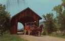
| Description: | Color postcard of a covered bridge at Stonefield Village with a horse bus passing through it. |
| Date: | 1914 |
|---|---|
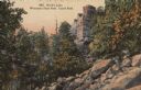
| Description: | Castle Rock at Devil's Lake, number 4801 in E.A. Bishop's Wisconsin State Park Series. Caption on back of postcard reads: "Our State Parks now rank among t... |

| Date: | 1950 |
|---|---|
| Description: | Intended for tourists, this brochure features two maps with tourists sites along the Mississippi River. One map shows roads and populated places along the ... |
| Date: | 1920 |
|---|---|
| Description: | Envelope cover. Inside are eighteen color enhanced photographic scenes from Door County, Wisconsin, including a short description of Door County features t... |

| Date: | 1939 |
|---|---|
| Description: | This illustrated map shows counties, highways, rivers, roads, present and proposed state parks and forests, proposed state parkways, proposed state monumen... |

| Date: | 1940 |
|---|---|
| Description: | This pictorial map shows points of interest, recreation activities, and highways in the vicinity of the restaurant and covers the Wisconsin River Valley be... |

| Date: | 1980 |
|---|---|
| Description: | This map shows the locations of 42 businesses, roads, points of interest, recreation sites, camping, the North Country Trail and parking, and boundaries of... |

| Date: | 1966 |
|---|---|
| Description: | This map includes a red overprint on base map and shows the supervisors and district numbers of St. Croix County. Includes diagrams of civil towns, townsh... |

| Date: | 1973 |
|---|---|
| Description: | This map shows cities, historical markers, interstate highways, U.S. highways, state highways, state parks and state forests. The original caption reads, "... |

| Date: | 1970 |
|---|---|
| Description: | This colored map displays a brief description of tourist attractions in the state, as well as a grid of state parks and recreational facilities. There is a... |
If you didn't find the material you searched for, our Library Reference Staff can help.
Call our reference desk at 608-264-6535 or email us at: