 Filter: Categories of Wisconsin Historical Images
Filter: Subject of State parks and reserves
Filter: Subject of streams
Filter: Categories of Wisconsin Historical Images
Filter: Subject of State parks and reserves
Filter: Subject of streams
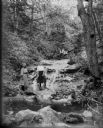
| Date: | 1910 |
|---|---|
| Description: | Two girls stand in the foreground, and a man and woman sit on a log over the stream in the background at the Parfrey's Glen waterfall near Devil's Lake. |
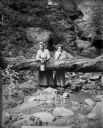
| Date: | 1909 |
|---|---|
| Description: | Two women pose behind a log which has fallen across the stream in Parfrey's Glen. One woman holds a small pail. |

| Date: | 1934 |
|---|---|
| Description: | An original lithograph promoting the national parks of the western United States and Canada, as well as promoting train travel. The poster depicts a creek... |

| Date: | 1948 |
|---|---|
| Description: | This outline map of Sauk County, Wisconsin, shows the towns, cities and villages, railroads, and streams in the county. |
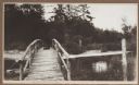
| Date: | 1915 |
|---|---|
| Description: | A rustic foot bridge over Fish Creek connects Peninsula State Park (foreground) with the village of Fish Creek. The Vits house is at the right end of the b... |
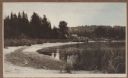
| Date: | 1915 |
|---|---|
| Description: | View from the Vits property, looking east, across a rustic foot bridge over Fish Creek leading to Peninsula State Park. A dachshund rests in the middle of ... |

| Date: | 1926 |
|---|---|
| Description: | Map showing Devil's Lake State Park limits, railroads, roads, creeks, trails, and park sites. Accompanying text about the location, natural features, attra... |

| Date: | 1935 |
|---|---|
| Description: | This 1935 map shows the Wisconsin River from a point approximately 4 miles south of the city of Wisconsin Dells north to Duck Creek in Adams County. Sectio... |

| Date: | 1987 |
|---|---|
| Description: | This 1987 map of Door County, Wisconsin, shows streets and roads, cities and villages, state parks, lakes and streams, and depths in Lake Michigan. A stree... |

| Date: | 1975 |
|---|---|
| Description: | This standard U.S.G.S. topographic map was annotated by civil engineer and railroad historian James P. Kaysen to show the location of existing and defunct ... |

| Date: | 07 19 1917 |
|---|---|
| Description: | View of a small foot bridge over a stream. This postcard was sent to a Miss M.S. Fester at the State Historical Library, who donated it on May 2, 1918. On ... |

| Date: | 1950 |
|---|---|
| Description: | Two girls and a boy are posing standing at the edge of the pool at Pewit's Nest. The boy has rolled the legs of his overalls above his knees. There are tal... |
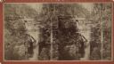
| Date: | |
|---|---|
| Description: | Elevated view stereograph of the dam at Pewit's Nest on Skillet Creek. Caption on reverse reads: "Devil's Lake and Wisconsin Scenery." |
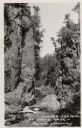
| Date: | 1950 |
|---|---|
| Description: | View of the Copper Canyon and the stream running through it. |
If you didn't find the material you searched for, our Library Reference Staff can help.
Call our reference desk at 608-264-6535 or email us at: