 Filter: Categories of Wisconsin Historical Images
Filter: Subject of State parks and reserves
Filter: Subject of mounds
Filter: Categories of Wisconsin Historical Images
Filter: Subject of State parks and reserves
Filter: Subject of mounds
| Date: | |
|---|---|
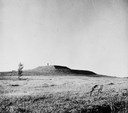
| Description: | View of the southwest pyramidal mound in Aztalan State Park as it appeared after restoration. A person is standing on top of the mound. |
| Date: | 1945 |
|---|---|
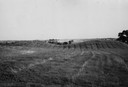
| Description: | Field with contours, and two mounds. |
| Date: | 1945 |
|---|---|
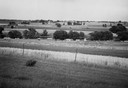
| Description: | Field prior to the park's reconstruction, with a fence in the foreground. A river is at the bottom of the hill. |
| Date: | |
|---|---|
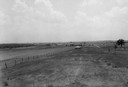
| Description: | View of Aztalan State Park site when it was called Aztalan Mound Park. |

| Date: | 1920 |
|---|---|
| Description: | A map of the Nelson-Dewey State Park at the confluence of the Mississippi and Wisconsin rivers, showing the topographical features of the area, as well as ... |

| Date: | 1920 |
|---|---|
| Description: | This 1920 map actually depicts present-day Wyalusing State Park at the confluence of the Mississippi and Wisconsin rivers in the Town of Wyalusing, Grant C... |

| Date: | |
|---|---|
| Description: | Photographic postcard view of one of the Indian mounds at Aztalan State Park. Steps lead up to the top of the mound from the right, and a tall fence is beh... |
| Date: | |
|---|---|
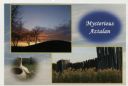
| Description: | Photographic postcard view of three views from Aztalan State Park; Indian Mound at sunset, pottery, and a fence. |
If you didn't find the material you searched for, our Library Reference Staff can help.
Call our reference desk at 608-264-6535 or email us at: