 Filter: Categories of Wisconsin Historical Images
Filter: Subject of State parks and reserves
Filter: Subject of land
Filter: Categories of Wisconsin Historical Images
Filter: Subject of State parks and reserves
Filter: Subject of land

| Date: | 1936 |
|---|---|
| Description: | This map shows campsites, trails, auto roads, surrounding townships, and points of interest, by including pictorial illustrations. Includes an inserted map... |

| Date: | 1949 |
|---|---|
| Description: | This map shows points of interest, historic sites, buildings, trails, roads, and general animal and plant locations. |
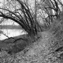
| Date: | 11 2013 |
|---|---|
| Description: | View down a small dirt path lined with grasses and trees along Ferry Bluff State Natural Area. To the left is Honey Creek leading to the Wisconsin River. |
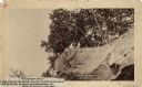
| Date: | 1888 |
|---|---|
| Description: | View looking up at three men and a child on top of a cliff on which are petroglyphs. Caption on photograph reads: "Pictograph Rock. Rock bearing aboriginal... |
| Date: | 1888 |
|---|---|
| Description: | View looking up at three men and a child on top of a cliff on which are petroglyphs. Pictograph Rock bearing aboriginal carvings, located on the south side... |
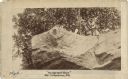
| Date: | 08 26 1913 |
|---|---|
| Description: | View through trees towards a man posing next to a large rock formation of a balancing rock. On the right is another rock formation. Below in the background... |
| Date: | 1898 |
|---|---|
| Description: | Colorized postcard of an elevated view of the Devil's Doorway rock formation at Devil's Lake State Park. Devil's Lake is below in the background. Caption r... |

| Date: | 1908 |
|---|---|
| Description: | Colorized elevated view of the Devil's Doorway rock formation. Caption reads: "Devils [sic] Doorway, Looking East, Devils [sic] Lake, Wis." |

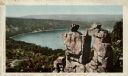
| Date: | |
|---|---|
| Description: | Colorized postcard of an elevated view of the rock formation near Devil's Lake. Caption at top reads: "Prospect Point, 610 FT. Above the Lake." Caption at ... |

| Date: | 1908 |
|---|---|
| Description: | Colorized postcard view of the Cleopatra's Needle rock formation, with Devil's Lake in the background. Caption reads: "Cleopatra's Needle, Devils [sic] La... |

| Date: | |
|---|---|
| Description: | Drawing of a map showing the cruise routes from Eagle Inn Dock and the points of interest. There is a schedule and rates on the reverse. |

| Date: | |
|---|---|
| Description: | View from water towards Eagle Cliff (Bluff) in Peninsula State Park Caption reads: "Eagle Cliff, Ephraim, Wis." |
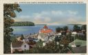
| Date: | 1935 |
|---|---|
| Description: | Hand-colored elevated view from hill of Ephraim, Eagle Bay and Peninsula State Park. Dwellings and a church are in the foreground. Caption reads: "Ephraim,... |

| Date: | 1944 |
|---|---|
| Description: | Elevated view of Fish Creek and Green Bay. Dwellings are in the foreground. The Peninsula State Park is across the bay. Caption reads: "Fish Creek, Wis. Fr... |
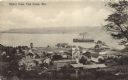
| Date: | 1910 |
|---|---|
| Description: | Elevated view from hill of Fish Creek and its harbor. A steamer is near the dock. The Peninsula State Park is across the bay. Caption reads: "Harbor View, ... |

| Date: | 1914 |
|---|---|
| Description: | A view from Beaver Bay in Lake Superior of houses on the shoreline. |
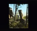
| Date: | 08 24 2014 |
|---|---|
| Description: | View from walkway of Stand Rock rising out of the bushes and trees surrounding the geological formation. A net is strung low between Stand Rock and the nea... |

| Date: | 09 07 2014 |
|---|---|
| Description: | View from the top of a hill looking out to a valley, with clouds in the blue sky. Trees are framing the view, and in the foreground, a woman, the photograp... |
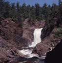
| Date: | |
|---|---|
| Description: | View of Brownstone Falls on Bad River. Rock formations are on the left and right banks. Trees are along the top of the rock formations. |
If you didn't find the material you searched for, our Library Reference Staff can help.
Call our reference desk at 608-264-6535 or email us at:
