 Filter: Categories of Wisconsin Historical Images
Filter: Subject of State parks and reserves
Filter: Subject of land
Filter: Categories of Wisconsin Historical Images
Filter: Subject of State parks and reserves
Filter: Subject of land

| Date: | |
|---|---|
| Description: | Photographic postcard of the railroad tracks around the East Shore of the lake in Devil's Lake State Park. Telephone poles are between the tracks and the s... |

| Date: | 06 04 1924 |
|---|---|
| Description: | Photographic postcard of rocks and trees above the lake in Devil's Lake State Park. Below on the left railroad tracks run along the shoreline. Trees and bl... |
| Date: | |
|---|---|
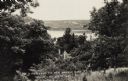
| Description: | Photographic postcard view from hill of Devil's Lake and bluffs seen through the trees. A roof and chimney are below the hill. The text at the bottom reads... |
| Date: | |
|---|---|
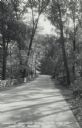
| Description: | Photographic postcard of the Warner Memorial Road in Devil's Lake State Park. Trees line both sides of the road, and there is a stone wall on the left. The... |
| Date: | 07 09 1908 |
|---|---|
| Description: | Black and white postcard of the rock formation called Castle Rock in Devil's Lake State Park. Trees can be seen throughout. The lake, bluffs and sky are vi... |

| Date: | 08 11 1906 |
|---|---|
| Description: | Black and white postcard of the rock formation called the Devil's Doorway in Devil's Lake State Park. Graffiti is visible on the formation. The lake, bluff... |

| Date: | |
|---|---|
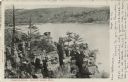
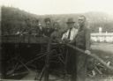
| Description: | Black and white postcard of the boat landing in front of Cliff House, a resort hotel, in Devil's Lake State Park. Two men show off their catch of seven fis... |
| Date: | 07 13 1906 |
|---|---|
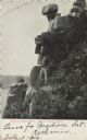
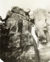
| Description: | Black and white photographic postcard of the rock formation called the Great Stone Face in Devil's Lake State Park. A man is standing to the right of the "... |
| Date: | |
|---|---|
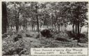
| Description: | Photographic postcard of picnic grounds at a spring in Blue Mounds State Park. The spring is running out of a brick catch basin on the right. A woman weari... |

| Date: | |
|---|---|
| Description: | Photographic postcard of the view to the west from the top of Blue Mounds, in Blue Mounds State Park. Handwritten is "Platteville Mounds, 45 miles" with an... |

| Date: | |
|---|---|
| Description: | Photographic postcard of the northwest view of Blue Mounds. Text below in a white box reads "N.W. View of Blue Mounds, Wis. Elevation 1760 ft." |

| Date: | |
|---|---|
| Description: | Photographic postcard of the view towards Madison from the top of Blue Mounds. Handwritten on the card is "State Capitol, 25 miles" with an arrow. Text bel... |

| Date: | 1935 |
|---|---|
| Description: | View of Bad River rushing over cliff at Copper Falls State Park. |
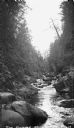
| Date: | 1935 |
|---|---|
| Description: | The Bad River flowing through boulders and a gorge. |
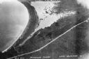
| Date: | 1934 |
|---|---|
| Description: | Aerial view of Big Bay on Madeline Island. This area later became Big Bay State Park. |
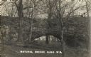
| Date: | 01 20 1914 |
|---|---|
| Description: | Photographic postcard of a geological formation called "Natural Bridge" in Natural Bridge State Park. |

| Date: | 1981 |
|---|---|
| Description: | Plat map of Madeline Island surrounded by Basswood, Michigan and Gull Islands. |

| Date: | 1935 |
|---|---|
| Description: | Civilian Conservation Corps workers at the Devil's Lake State park camp waving from trucks. Others men stand in the dirt road nearby. |
| Date: | 1935 |
|---|---|
| Description: | Devil's Lake State Park Civilian Conservation Corps workers posed at rock formation, possibly Devil's Doorway. |
| Date: | 1935 |
|---|---|
| Description: | Group of Civilian Conservation Corps workers standing at a table saw. One man, probably a supervisor, wears a hat and tie. |
If you didn't find the material you searched for, our Library Reference Staff can help.
Call our reference desk at 608-264-6535 or email us at: