 Filter: Categories of Wisconsin Historical Images
Filter: Subject of State parks and reserves
Filter: Subject of land
Filter: Subject of roads
Filter: Categories of Wisconsin Historical Images
Filter: Subject of State parks and reserves
Filter: Subject of land
Filter: Subject of roads

| Date: | 1939 |
|---|---|
| Description: | A color, pictorial map. Scale: 10 miles to the inch. Shows state parks and forests, proposed state parkways, proposed state monuments and memorials, nation... |

| Date: | |
|---|---|
| Description: | Elevated view of the lake at Bear Mountain Park, with trees in the background and a road bordering one side. |
| Date: | |
|---|---|
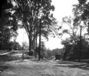
| Description: | View toward a boy with his bicycle at the entrance to Putnam Hill Park on the left. There are telephone poles and trees in the center, street railroad trac... |

| Date: | |
|---|---|
| Description: | Elevated view from rocks overlooking a valley toward Devil's Lake. Several houses are near a road that leads to the shoreline. |
| Date: | 1956 |
|---|---|
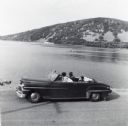
| Description: | Lewis, LuRay, Nellie and Bernard Arms arrive at Devil's Lake in a maroon DeSoto convertible automobile. This was the day after Lewis and LuRay's wedding. |

| Date: | 1914 |
|---|---|
| Description: | Colorized postcard of the rock formation called the Devil's Doorway in Devil's Lake State Park. Trees can be seen below. The lake, bluffs, roads and buildi... |

| Date: | 12 29 1909 |
|---|---|
| Description: | Colorized postcard of the rock formation called the Devil's Doorway in Devil's Lake State Park. Trees are on the left and below. Bluffs, trees, sky and a r... |

| Date: | 06 28 1912 |
|---|---|
| Description: | Colorized postcard view of the rock formation called the Devil's Doorway in Devil's Lake State Park. Trees are growing among the rocks. The lake, bluffs, b... |
| Date: | |
|---|---|
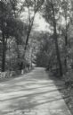
| Description: | Photographic postcard of the Warner Memorial Road in Devil's Lake State Park. Trees line both sides of the road, and there is a stone wall on the left. The... |
| Date: | 1934 |
|---|---|
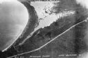
| Description: | Aerial view of Big Bay on Madeline Island. This area later became Big Bay State Park. |

| Date: | 1935 |
|---|---|
| Description: | Civilian Conservation Corps workers at the Devil's Lake State park camp waving from trucks. Others men stand in the dirt road nearby. |

| Date: | 1994 |
|---|---|
| Description: | This brochure consists of a series of 16 maps of the Military Ridge State Park Trail and the Sugar River State Trail. In all, 62 miles of bike trails and 1... |

| Date: | 1936 |
|---|---|
| Description: | This pictorial tourist map from the Wisconsin Conservation Commission depicts vacation activities and identifies tourist destinations throughout the state.... |
| Date: | 1920 |
|---|---|
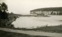
| Description: | Several boats are moored in the protected harbor. An old warehouse stands on a pier. A tall bluff and rock cliff dominates the opposite shoreline. |

| Date: | 1920 |
|---|---|
| Description: | A map of the Nelson-Dewey State Park at the confluence of the Mississippi and Wisconsin rivers, showing the topographical features of the area, as well as ... |

| Date: | 1920 |
|---|---|
| Description: | This 1920 map actually depicts present-day Wyalusing State Park at the confluence of the Mississippi and Wisconsin rivers in the Town of Wyalusing, Grant C... |

| Date: | 1926 |
|---|---|
| Description: | This Wisconsin Conservation Commission map from the 1920s shows roads, railroads, campsites, lookout towers, and privately owned lands in Northern Forest S... |

| Date: | 1916 |
|---|---|
| Description: | This Wisconsin Conservation Commission map from 1916 shows Peninsula State Park in the Town of Gibraltar, Door County, Wisconsin. Depicted are open and pla... |

| Date: | 1916 |
|---|---|
| Description: | This version of a 1916 Wisconsin Conservation Commission map shows Peninsula State Park in the Town of Gibraltar, Door County, Wisconsin. Depicted are open... |

| Date: | 1990 |
|---|---|
| Description: | This late 20th century tourist map of Sauk County, Wisconsin, shows the highways and roads, cities and towns, parks, airports, canoe landings, hospitals, s... |
If you didn't find the material you searched for, our Library Reference Staff can help.
Call our reference desk at 608-264-6535 or email us at: