 Filter: Categories of Wisconsin Historical Images
Filter: Subject of State parks and reserves
Filter: Subject of dams
Filter: Categories of Wisconsin Historical Images
Filter: Subject of State parks and reserves
Filter: Subject of dams
| Date: | |
|---|---|
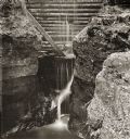
| Description: | Elevated view of dam at Pewit's Nest on Skillet Creek. |

| Date: | 02 1956 |
|---|---|
| Description: | This 1956 map of Waukesha County, Wisconsin, shows the township and range grid, towns, sections, cities and villages, roads, railroads, dams, airports, par... |

| Date: | 1935 |
|---|---|
| Description: | View towards an unidentified woman sitting and facing away from the camera to take in the view of the St. Croix River from a high rock formation. The bridg... |
| Date: | |
|---|---|
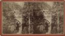
| Description: | Elevated view stereograph of the dam at Pewit's Nest on Skillet Creek. Caption on reverse reads: "Devil's Lake and Wisconsin Scenery." |
| Date: | |
|---|---|
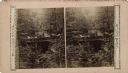
| Description: | Stereograph of a scene at Pewit's Nest. Text on front reads: "Wisconsin Views, Devil's Lake." |
If you didn't find the material you searched for, our Library Reference Staff can help.
Call our reference desk at 608-264-6535 or email us at: