 Filter: Categories of Wisconsin Historical Images
Filter: Subject of State parks and reserves
Filter: Subject of camps
Filter: Categories of Wisconsin Historical Images
Filter: Subject of State parks and reserves
Filter: Subject of camps
| Date: | |
|---|---|
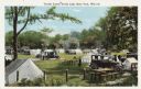
| Description: | Colorized postcard of a tourist camp at Devil's Lake State Park. Features a scene of men, women and children among picnic tables, automobiles. Tents are pi... |
| Date: | 08 16 1935 |
|---|---|
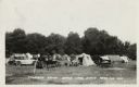
| Description: | Photographic postcard of a tourist camp at Devil's Lake State Park. A scene of picnic tables, automobiles and tents pitched among trees and grass. Text at ... |
| Date: | 1960 |
|---|---|
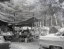
| Description: | A campsite at Hiawatha National Forest. Men and women sits at a picnic table, while children sit by the campfire. |

| Date: | 1937 |
|---|---|
| Description: | This Wisconsin Conservation Department map shows the locations of state forests, national forests, county forests, state nurseries, Indian reservations, st... |

| Date: | 1926 |
|---|---|
| Description: | This Wisconsin Conservation Commission map from the 1920s shows roads, railroads, campsites, lookout towers, and privately owned lands in Northern Forest S... |

| Date: | 1916 |
|---|---|
| Description: | This Wisconsin Conservation Commission map from 1916 shows Peninsula State Park in the Town of Gibraltar, Door County, Wisconsin. Depicted are open and pla... |

| Date: | 1916 |
|---|---|
| Description: | This version of a 1916 Wisconsin Conservation Commission map shows Peninsula State Park in the Town of Gibraltar, Door County, Wisconsin. Depicted are open... |

| Date: | 1952 |
|---|---|
| Description: | This map shows roads, foot and canoe trails, railroads, resorts, lookout towers, camps, national and state forests, Indian reservation, and types of fish i... |

| Date: | 1987 |
|---|---|
| Description: | This map shows federal highways, state or county highways, rivers, lakes, town roads, township boundaries, county boundaries, national or state forest, loo... |
| Date: | |
|---|---|
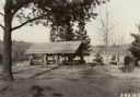
| Description: | Caption reads: "Shelter, pump, and carving log at Wanoka Camp Ground on the Chequamegon National Forest." |
If you didn't find the material you searched for, our Library Reference Staff can help.
Call our reference desk at 608-264-6535 or email us at: