 Filter: Categories of Wisconsin Historical Images
Filter: Subject of State parks and reserves
Filter: Subject of camping
Filter: Categories of Wisconsin Historical Images
Filter: Subject of State parks and reserves
Filter: Subject of camping
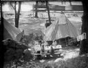
| Date: | 1919 |
|---|---|
| Description: | Elevated view of the Herman Taylor family camping at Devil's Lake. There is a moving train in the background on railroad tracks along the shoreline of the ... |

| Date: | 07 1876 |
|---|---|
| Description: | A camping party rests at the top of a bluff at Devil's Lake State Park. |

| Date: | |
|---|---|
| Description: | Sigurd Olson, in typical camping attire, during a canoe trip at Quetico Park in Canada. |
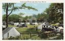
| Date: | |
|---|---|
| Description: | Colorized postcard of a tourist camp at Devil's Lake State Park. Features a scene of men, women and children among picnic tables, automobiles. Tents are pi... |
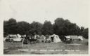
| Date: | 08 16 1935 |
|---|---|
| Description: | Photographic postcard of a tourist camp at Devil's Lake State Park. A scene of picnic tables, automobiles and tents pitched among trees and grass. Text at ... |
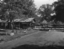
| Date: | 1925 |
|---|---|
| Description: | An information station advertising: free camping, with hot sandwiches and coffee, and tents and cots for sale. On a utility line pole, there are signs for ... |

| Date: | 1968 |
|---|---|
| Description: | The map shows fire towers, public camp grounds, roads, snow mobile & riding trails, trout lakes, foot trails, railroads, and National Forest boundaries. |
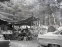
| Date: | 1960 |
|---|---|
| Description: | A campsite at Hiawatha National Forest. Men and women sits at a picnic table, while children sit by the campfire. |

| Date: | 1960 |
|---|---|
| Description: | Three men holding archery equipment at a campsite in Hiawatha National Forest. |
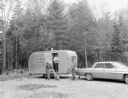
| Date: | 1960 |
|---|---|
| Description: | Two men, a woman, and a dog at a trailer in Hiawatha National Forest. |

| Date: | 1975 |
|---|---|
| Description: | A tourist map of Grant County that displays the various activities and attractions found in the cities throughout the county, such as boat landings, fishin... |

| Date: | 1923 |
|---|---|
| Description: | This topographical map of Devil's Lake State Park, Sauk County, Wisconsin, is based on 1922-1923 surveys of the area by the University of Wisconsin Summer ... |

| Date: | 1971 |
|---|---|
| Description: | This map of Nelson Dewey State Park shows the park layout, points of interest, facilities, campgrounds, roads, railroads, and the Mississippi River. Relief... |

| Date: | 1980 |
|---|---|
| Description: | This map shows the locations of 42 businesses, roads, points of interest, recreation sites, camping, the North Country Trail and parking, and boundaries of... |

| Date: | 2000 |
|---|---|
| Description: | This map shows national parks, county and state forests, Indian reservations, municipal land, private land, docks, boat access, camping, and points of inte... |
| Date: | 1924 |
|---|---|
| Description: | This map shows road surfacings, camp sites, state parks, proposed state parks, rivers, lakes, towns, and county boundaries. Includes a legend of road surfa... |

| Date: | 1926 |
|---|---|
| Description: | This map shows road surfacings, camp sites, state parks, proposed state parks, rivers, lakes, county boundaries, and cities. Includes portions of Minnesota... |

| Date: | 1966 |
|---|---|
| Description: | This map includes a red overprint on base map and shows the supervisors and district numbers of St. Croix County. Includes diagrams of civil towns, townsh... |

| Date: | 1987 |
|---|---|
| Description: | This map shows county forests, state, federal, and interstate highways. County forests lands are shown in light green. The front of the map includes images... |

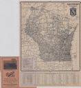
| Date: | 1929 |
|---|---|
| Description: | This map of the entire state includes portions of Illinois, Iowa, Michigan, and Minnesota. The map shows U.S., state, and county highways, roads, campsites... |
If you didn't find the material you searched for, our Library Reference Staff can help.
Call our reference desk at 608-264-6535 or email us at: