 Filter: Categories of Wisconsin Historical Images
Filter: Subject of State parks and reserves
Filter: County of Door
Filter: Year of 1900-1999
Filter: Categories of Wisconsin Historical Images
Filter: Subject of State parks and reserves
Filter: County of Door
Filter: Year of 1900-1999
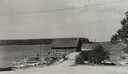
| Date: | 1935 |
|---|---|
| Description: | View down road towards boats docked at the fishing wharf at Ephraim in Door County. The bluff on the horizon is in Peninsula State Park. |
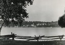
| Date: | 1950 |
|---|---|
| Description: | Downtown Ephraim from Peninsula State Park, directly across the bay. |

| Date: | 1954 |
|---|---|
| Description: | View looking west from Eagle Bluff toward Nicolet Bay, the Strawberry Islands, and Chambers Island. Three people are sitting on the stone wall of the overl... |
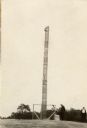
| Date: | 1930 |
|---|---|
| Description: | A totem pole erected in 1927 in honor of the aboriginal inhabitants of Wisconsin. Potawatomi chief Simon Onanguisse Kahquados (1851-November 27, 1930), an ... |
| Date: | 1960 |
|---|---|
| Description: | Cottage built by Marie Gatter beginning in the 1920s along the shore road in the park. It was razed in the winter of 1960-61. The chimney was originally pa... |
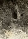
| Date: | 1940 |
|---|---|
| Description: | A view of some caves at Peninsula State Park. |
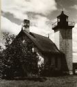
| Date: | 1940 |
|---|---|
| Description: | A rear view of the Eagle Harbor Lighthouse at Peninsula State Park. |
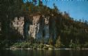
| Date: | 1960 |
|---|---|
| Description: | View across water towards the 180-foot high Eagle Bluff. The bluff received its name from the eagles which formerly nested there. |
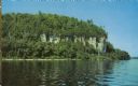
| Date: | 1960 |
|---|---|
| Description: | View across water towards the 180-foot high Eagle Bluff. The bluff received its name from the eagles which formerly nested there. |
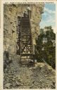
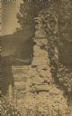
| Date: | 1910 |
|---|---|
| Description: | View of the steps leading to Eagle Cave on Eagle Bluff. The bluff received its name from the eagles which formerly nested there. Caption reads: "Scene at E... |
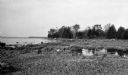
| Date: | 1925 |
|---|---|
| Description: | Rocky shoreline at Nelson Point, now in Peninsula State Park. |

| Date: | 1923 |
|---|---|
| Description: | A small cottage is barely visible through the trees on the rocky shore at Nelson Point, now part of Peninsula State Park. |
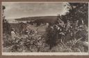
| Date: | 1920 |
|---|---|
| Description: | A well-dressed man identified as Uncle Rudolph Schenck takes in the view from a bluff overlooking the Fish Creek valley and harbor. There are houses and ou... |
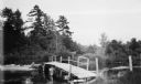
| Date: | 1912 |
|---|---|
| Description: | A footbridge crossing Fish Creek into Peninsula Stat Park. |
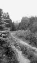
| Date: | 1925 |
|---|---|
| Description: | A dirt road winds through Peninsula State Park. |

| Date: | 1916 |
|---|---|
| Description: | This Wisconsin Conservation Commission map from 1916 shows Peninsula State Park in the Town of Gibraltar, Door County, Wisconsin. Depicted are open and pla... |

| Date: | 1916 |
|---|---|
| Description: | This version of a 1916 Wisconsin Conservation Commission map shows Peninsula State Park in the Town of Gibraltar, Door County, Wisconsin. Depicted are open... |

| Date: | 1930 |
|---|---|
| Description: | Aerial view looking north across the wooded peninsula separating Europe Bay (top) from Newport Bay. This area is now part of Newport State Park. |

| Date: | 1930 |
|---|---|
| Description: | Aerial view of the northern tip of the Door Peninsula, looking north. Europe Lake is in the center, with Europe Bay to the right. Plum Island and Washingto... |

| Date: | 1930 |
|---|---|
| Description: | Aerial view looking northeast, with Rowley's Bay in the foreground. Europe Lake is to the left, with Europe Bay and Newport Bay separated by a narrow peni... |
If you didn't find the material you searched for, our Library Reference Staff can help.
Call our reference desk at 608-264-6535 or email us at: