Filter: Categories of Wisconsin Historical Images
Filter: Subject of State parks and reserves
Filter: Community of Wisconsin Dells
Filter: Year of 1900-1999
Filter: Categories of Wisconsin Historical Images
Filter: Subject of State parks and reserves
Filter: Community of Wisconsin Dells
Filter: Year of 1900-1999
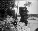
| Date: | 1910 |
|---|---|
| Description: | View across Wisconsin River of men and women in canoes at the base of Lone Rock at the Dells. |
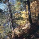
| Date: | 1950 |
|---|---|
| Description: | Hillside path at Narrows during the Fall. The river is visible beyond trees on the left. |
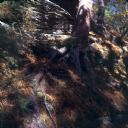
| Date: | 1950 |
|---|---|
| Description: | Pine tree on hillside path at Narrows during the Fall. |

| Date: | 1900 |
|---|---|
| Description: | Three people and a young child sitting around a stone table in Luncheon Hall. Text at right: "Wanderings Among the Wonders and Beauties of Wisconsin Scener... |

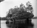
| Date: | 1903 |
|---|---|
| Description: | Two men canoeing at Steamboat Rock. Text at right: "Wanderings Among the Wonders and Beauties of Wisconsin Scenery." |

| Date: | 1935 |
|---|---|
| Description: | This 1935 map shows the Wisconsin River from a point approximately 4 miles south of the city of Wisconsin Dells north to Duck Creek in Adams County. Sectio... |
If you didn't find the material you searched for, our Library Reference Staff can help.
Call our reference desk at 608-264-6535 or email us at: