 Filter: Categories of Wisconsin Historical Images
Filter: Subject of Stadiums
Filter: Subject of roads
Filter: Categories of Wisconsin Historical Images
Filter: Subject of Stadiums
Filter: Subject of roads

| Date: | 1949 |
|---|---|
| Description: | Color bird's-eye map of the University of Wisconsin-Madison as it was midcentury, with two co-eds, several photographs of campus landmarks around edges, an... |

| Date: | |
|---|---|
| Description: | Aerial view of a full Camp Randall Stadium during half-time of a football game. The band is on the field in formation to spell "UW." |

| Date: | 02 06 1948 |
|---|---|
| Description: | Looking southeast across Speedway Road. Visible are the reservoir on Glenway Street, Hoyt Park, Resurrection and Forest Hill cemeteries, Glenway Golf cours... |
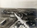
| Date: | 1907 |
|---|---|
| Description: | Elevated wiew looking west, probably from the chimney of the University of Wisconsin Power Plant. Camp Randall Stadium is in the lower left corner. |

| Date: | 1945 |
|---|---|
| Description: | Aerial view of married student housing located next to the baseball field near Camp Randall stadium and the Field House. |

| Date: | 1959 |
|---|---|
| Description: | University of Wisconsin-Madison campus. Numbers in circles identify buildings across campus with the building index. Black arrows point out important infor... |

| Date: | 1968 |
|---|---|
| Description: | A tourist map of Milwaukee County and of downtown Milwaukee. The Map of Milwaukee County identifies the location of some of the points of interests in the ... |
If you didn't find the material you searched for, our Library Reference Staff can help.
Call our reference desk at 608-264-6535 or email us at: