 Filter: Categories of Wisconsin Historical Images
Filter: Subject of Snowmobiling
Filter: Subject of water
Filter: Categories of Wisconsin Historical Images
Filter: Subject of Snowmobiling
Filter: Subject of water

| Date: | 1970 |
|---|---|
| Description: | This map is intended for tourists of La Crosse. The cover features images of farms and natural land and reads: "friends are but strangers... we have yet to... |

| Date: | 1983 |
|---|---|
| Description: | This map covers Vilas county as well as parts of Iron, Oneida, and Forest counties. Club trails are shown in dotted red lines and state trails are shown in... |

| Date: | 1994 |
|---|---|
| Description: | This map shows historical sites, picnic grounds, public boat landings, canoe and motor boat trips, and resort locations. The left margin of the map include... |
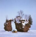
| Date: | |
|---|---|
| Description: | View across frozen bay towards a person riding a snowmobile in front of a split rock formation on Chequamegon Bay. |
If you didn't find the material you searched for, our Library Reference Staff can help.
Call our reference desk at 608-264-6535 or email us at: