 Filter: Categories of Wisconsin Historical Images
Filter: Subject of Snow
Filter: County of Dane
Filter: Subject of aerial photographs
Filter: Categories of Wisconsin Historical Images
Filter: Subject of Snow
Filter: County of Dane
Filter: Subject of aerial photographs

| Date: | 02 06 1948 |
|---|---|
| Description: | Aerial photograph of Madison's west side looking northeast along Speedway Road. Visible are Forest Hill and Resurrection Cemeteries, West High School, Hoyt... |

| Date: | 02 06 1948 |
|---|---|
| Description: | Aerial view of west side, looking south along Glenway Street. Visible are the reservoir, Lake Wingra, Forest Hill and Resurrection Cemetery, Hoyt Park. Maj... |

| Date: | 02 06 1948 |
|---|---|
| Description: | Aerial photograph looking northwest across the reservoir on Glenway Street. Featured are Hoyt and Quarry Parks, Resurrection Cemetery. Major streets are Fr... |

| Date: | 02 06 1948 |
|---|---|
| Description: | Looking north along Glenway Street. Visible are the reservoir, Hoyt and Quarry Parks, Resurrection and Forest Hill Cemeteries, Rentschler Greenhouses, Fore... |

| Date: | 02 06 1948 |
|---|---|
| Description: | Looking southeast across Speedway Road. Visible are the reservoir on Glenway Street, Hoyt Park, Resurrection and Forest Hill cemeteries, Glenway Golf cours... |

| Date: | 02 06 1948 |
|---|---|
| Description: | Looking east along Regent Street with snow on the ground. Visible are Lake Wingra, Monona Bay, railroad causeway across Monona, Lake Mendota, Hoyt Park, We... |
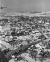
| Date: | 01 22 1949 |
|---|---|
| Description: | Aerial view of the town and the Chicago, Milwaukee, St. Paul and Pacific railroad bridge. |

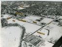
| Date: | 02 09 1949 |
|---|---|
| Description: | Three aerial views of the John Fluckiger farm and farm buildings amid snow-covered fields near Verona, operated by son Ivan Fluckiger. |

| Date: | 02 09 1949 |
|---|---|
| Description: | One of three aerial views of the E.P. Gallagher farm in the snow, operated by Elmer Fosso, south of Oregon. |

| Date: | 02 09 1949 |
|---|---|
| Description: | One of four aerial views of the Edwin Blaney farm and farm buildings surrounded by snow-covered fields. Four miles south of Madison and a mile west of U.S.... |

| Date: | 02 25 1949 |
|---|---|
| Description: | One of six aerial images of Mount Horeb. |
| Date: | 1965 |
|---|---|
| Description: | Aerial view of the UW-Madison campus near University Bay in winter. Labels are pasted to the print to indicate Elm Dr., the gym, Camp Randall Stadium, the ... |

| Date: | 12 23 1954 |
|---|---|
| Description: | Aerial view of the intersection of the West Beltline Highway and Verona Road (Highways 18-151). Includes Vikingtown Motel, town of Madison hall, Ballweg's ... |

| Date: | 03 28 1959 |
|---|---|
| Description: | Elevated view of a parking lot along John Nolen Drive on the shore of a partially frozen Lake Monona. Railroad tracks are in the foreground on the right. |

| Date: | 1962 |
|---|---|
| Description: | Air view in winter of the Triangle Redevelopment Project looking east with Regent Street running along the left edge, W. Washington Avenue along the top, a... |

| Date: | |
|---|---|
| Description: | Aerial view of the Greenbush neighborhood in winter partially demolished for the Triangle Redevelopment Project. Monona Bay and Brittingham park are at rig... |
If you didn't find the material you searched for, our Library Reference Staff can help.
Call our reference desk at 608-264-6535 or email us at: