 Filter: Categories of Wisconsin Historical Images
Filter: Subject of Skis and skiing
Filter: Subject of service industries
Filter: Categories of Wisconsin Historical Images
Filter: Subject of Skis and skiing
Filter: Subject of service industries
| Date: | |
|---|---|
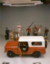
| Description: | Color advertising photograph depicting people in various professions and walks of life surrounding a new International Scout. |
| Date: | |
|---|---|
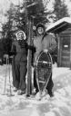
| Description: | Winter scene with Mary and Nelson Ross of Ross' Teal Lake Lodge. They are posing in the snow with skis and snowshoes. |
| Date: | |
|---|---|
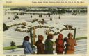
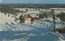
| Description: | Five people are standing at a fence rail looking down at King's Gateway Hotel. Caption reads: "Winter View at King's Gateway Hotel from the Top of the Ski ... |

| Date: | |
|---|---|
| Description: | View of a mail carrier using skis and a walking stick to navigate the snow of Mount Tab. The man carries a backpack and a dog sits at his feet. |
| Date: | |
|---|---|
| Description: | Color postcard of the Chalet at Mt. Telemark. Skiers and skis are in front of the Chalet. |
| Date: | |
|---|---|
| Description: | Color postcard of an elevated view of the Chalet at Mt. Telemark and surrounding area, and many skiers and several ski lifts. |
| Date: | 10 1947 |
|---|---|
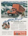
| Description: | Advertising proof for International trucks, featuring a color illustration of a Model KBR-11 truck-tractor with semi-trailer. Includes the text: "Winter Tr... |
| Date: | |
|---|---|
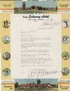
| Description: | Letterhead of the King's Gateway Hotel of Land O' Lakes, Wisconsin, with header and footer color views of the hotel and neighboring Gateway Inn. There are ... |
| Date: | |
|---|---|
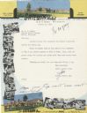
| Description: | Letterhead of the King's Gateway Hotel in Land O' Lakes, Wisconsin, with header and footer views of the hotel and nearby Gateway Inn in color, and overlapp... |

| Date: | 1970 |
|---|---|
| Description: | This map is intended for tourists of La Crosse. The cover features images of farms and natural land and reads: "friends are but strangers... we have yet to... |
| Date: | 02 19 1949 |
|---|---|
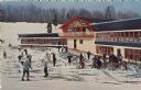
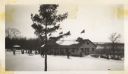
| Description: | Rib Mountain Ski Lodge. There are a number of skiers on the left, and people stand near the lodge. Cars are parked on the right. |

| Date: | 1969 |
|---|---|
| Description: | This map shows ski areas, resorts, camps, special areas, airports, and roads. The map covers Vilas and Oneida counties and parts of Iron, Price, Lincoln, L... |

| Date: | 2006 |
|---|---|
| Description: | This map includes indexed advertisements and map of the Lac du Flambeau region on back. The map is broken into 9 zones, each marked with state and club tra... |

| Date: | 1960 |
|---|---|
| Description: | This pictorial map shows recreation activities, rivers, lakes, and the history of the area. The map covers Langlade County and parts of adjacent counties. ... |

| Date: | 1983 |
|---|---|
| Description: | This map covers Vilas county as well as parts of Iron, Oneida, and Forest counties. Club trails are shown in dotted red lines and state trails are shown in... |

| Date: | 1966 |
|---|---|
| Description: | This colored road map shows automobile roads in Wisconsin as well as portions of nearby states. A map key indicates relative sizes of cities and towns. On ... |

| Date: | 1966 |
|---|---|
| Description: | This colored road map shows automobile roads in Wisconsin as well as portions of nearby states. Information on the quality and type of any road shown (inte... |

| Date: | 1972 |
|---|---|
| Description: | This colored map displays Wisconsin and bordering areas of Iowa, Minnesota, and Michigan. There is color-coding on the map to indicate National Forests, an... |

| Date: | 1970 |
|---|---|
| Description: | This colored map displays detailed maps of Green Bay, Appleton, Racine, Milwaukee, Kenosha, and Duluth-Superior. At the top right is a map location list of... |

| Date: | 1971 |
|---|---|
| Description: | This colored map displays Wisconsin and bordering areas of Iowa, Minnesota, and Michigan. There is color-coding on the map to indicate National Forests, an... |
If you didn't find the material you searched for, our Library Reference Staff can help.
Call our reference desk at 608-264-6535 or email us at: