 Filter: Categories of Wisconsin Historical Images
Filter: Subject of Skis and skiing
Filter: Subject of rivers
Filter: Categories of Wisconsin Historical Images
Filter: Subject of Skis and skiing
Filter: Subject of rivers
| Date: | 1918 |
|---|---|
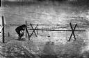
| Description: | Outdoor view of a U.S. Army Engineer topographer wearing skis while in the process of surveying land. The engineer is standing next to a barbed wire obstac... |

| Date: | 1918 |
|---|---|
| Description: | Outdoor view of a U.S. Army Engineer topographer wearing skis while using a tripod stand to write. The engineer is standing next to a barbed wire obstacle ... |

| Date: | 1970 |
|---|---|
| Description: | This map is intended for tourists of La Crosse. The cover features images of farms and natural land and reads: "friends are but strangers... we have yet to... |

| Date: | 1960 |
|---|---|
| Description: | This pictorial map shows recreation activities, rivers, lakes, and the history of the area. The map covers Langlade County and parts of adjacent counties. ... |

| Date: | 1987 |
|---|---|
| Description: | This map shows federal highways, state or county highways, rivers, lakes, town roads, township boundaries, county boundaries, national or state forest, loo... |

| Date: | 1983 |
|---|---|
| Description: | This map covers Vilas county as well as parts of Iron, Oneida, and Forest counties. Club trails are shown in dotted red lines and state trails are shown in... |
If you didn't find the material you searched for, our Library Reference Staff can help.
Call our reference desk at 608-264-6535 or email us at: