 Filter: Categories of Wisconsin Historical Images
Filter: Subject of Skis and skiing
Filter: Subject of recreation areas
Filter: Categories of Wisconsin Historical Images
Filter: Subject of Skis and skiing
Filter: Subject of recreation areas
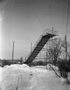
| Date: | 01 22 1949 |
|---|---|
| Description: | New junior ski jump at Hoyt Park. The jump is thirty-five feet high and is estimated to allow up to sixty-foot jumps under ideal conditions. |
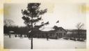
| Date: | 02 19 1949 |
|---|---|
| Description: | Rib Mountain Ski Lodge. There are a number of skiers on the left, and people stand near the lodge. Cars are parked on the right. |

| Date: | 01 29 1956 |
|---|---|
| Description: | Hill captain Werner Schorr supervises the removal of snow in Vilas Park to transport to the Blackhawk Ski Club's Tomahawk Ridge for the upcoming jumping to... |

| Date: | 02 03 1956 |
|---|---|
| Description: | Bob Narowetz takes off from the top of the jump scaffold at the annual Blackhawk Ski Club jumping tournament at their Tomahawk Ridge site. |

| Date: | 02 03 1956 |
|---|---|
| Description: | Hill captain Werner Schorr smooths snow near the base of the ski jump scaffold during the Blackhawk Ski Club's annual jumping tournament at their Tomahawk ... |

| Date: | 02 03 1956 |
|---|---|
| Description: | Moritz Schorr spreads cinders on the slippery steps of the ski jump scaffold during the Blackhawk Ski Club's annual jumping tournament at their Tomahawk Ri... |

| Date: | 01 03 1964 |
|---|---|
| Description: | Jim Remington, 15-years-old, lands after his jump at the junior ski meet at Hoyt park, sponsored by the Blackhawk Ski Club. |

| Date: | 1962 |
|---|---|
| Description: | This map shows roads, golf courses, ski areas, boat landings, camp sites, waysides, parks, beaches, scenic views, virgin timber tracts, airports, boys and ... |

| Date: | 1966 |
|---|---|
| Description: | This colored road map shows automobile roads in Wisconsin as well as portions of nearby states. A map key indicates relative sizes of cities and towns. On ... |

| Date: | 1966 |
|---|---|
| Description: | This colored road map shows automobile roads in Wisconsin as well as portions of nearby states. Information on the quality and type of any road shown (inte... |

| Date: | 1972 |
|---|---|
| Description: | This colored map displays Wisconsin and bordering areas of Iowa, Minnesota, and Michigan. There is color-coding on the map to indicate National Forests, an... |

| Date: | 1970 |
|---|---|
| Description: | This colored map displays detailed maps of Green Bay, Appleton, Racine, Milwaukee, Kenosha, and Duluth-Superior. At the top right is a map location list of... |

| Date: | 1971 |
|---|---|
| Description: | This colored map displays Wisconsin and bordering areas of Iowa, Minnesota, and Michigan. There is color-coding on the map to indicate National Forests, an... |

| Date: | 1973 |
|---|---|
| Description: | This colored map displays Wisconsin and bordering areas of Iowa, Minnesota, and Michigan. There is color-coding on the map to indicate National Forests, a... |

| Date: | 1975 |
|---|---|
| Description: | This colored road map of Wisconsin displays "Featured Points of Interest" and "Historical Points of Interest" in the state, including three color photograp... |

| Date: | 1973 |
|---|---|
| Description: | This map displays, in color, Wisconsin and bordering areas of Iowa, Minnesota, Illinois, and Michigan. At the bottom is a map key indicating road classifi... |

| Date: | 1976 |
|---|---|
| Description: | This color map displays Wisconsin and bordering areas of Iowa, Minnesota, Illinois, and Michigan. At the bottom is a map key indicating road classification... |

| Date: | 1976 |
|---|---|
| Description: | This colored map displays Wisconsin and portions of bordering states, including a detailed map of the Wisconsin Dells area. Surrounding the map are multipl... |

| Date: | 1977 |
|---|---|
| Description: | This colored map displays Wisconsin and portions of bordering states, including a detailed map of the Wisconsin Dells area. Surrounding the map are multipl... |

| Date: | 1962 |
|---|---|
| Description: | This colored map represents "Tour #2" of a series of driving tours of the state published by the Sperry & Hutchinson Company, in order to "help you enjoy W... |
If you didn't find the material you searched for, our Library Reference Staff can help.
Call our reference desk at 608-264-6535 or email us at: