 Filter: Categories of Wisconsin Historical Images
Filter: Subject of Skis and skiing
Filter: Subject of outdoor life
Filter: Categories of Wisconsin Historical Images
Filter: Subject of Skis and skiing
Filter: Subject of outdoor life
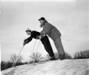
| Date: | 01 20 1948 |
|---|---|
| Description: | Two teenage skiers poised at the top of the hill at Blackhawk Ski Run. Hartman Axley is on the left and Bob Herman on the right. |
| Date: | |
|---|---|
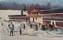
| Description: | Color postcard of the Chalet at Mt. Telemark. Skiers and skis are in front of the Chalet. |
| Date: | |
|---|---|
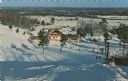
| Description: | Color postcard of an elevated view of the Chalet at Mt. Telemark and surrounding area, and many skiers and several ski lifts. |
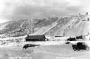
| Date: | 1935 |
|---|---|
| Description: | View of Mount Valhalla during the winter near Washburn. There is a building and a few automobiles parked at the bottom of a large hill covered in snow. The... |
| Date: | |
|---|---|
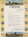
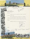
| Description: | Letterhead of the King's Gateway Hotel of Land O' Lakes, Wisconsin, with header and footer color views of the hotel and neighboring Gateway Inn. There are ... |
| Date: | |
|---|---|
| Description: | Letterhead of the King's Gateway Hotel in Land O' Lakes, Wisconsin, with header and footer views of the hotel and nearby Gateway Inn in color, and overlapp... |

| Date: | 1970 |
|---|---|
| Description: | This map is intended for tourists of La Crosse. The cover features images of farms and natural land and reads: "friends are but strangers... we have yet to... |

| Date: | 1966 |
|---|---|
| Description: | This colored road map shows automobile roads in Wisconsin as well as portions of nearby states. A map key indicates relative sizes of cities and towns. On ... |

| Date: | 1971 |
|---|---|
| Description: | This colored map displays Wisconsin and bordering areas of Iowa, Minnesota, and Michigan. There is color-coding on the map to indicate National Forests, an... |

| Date: | 1973 |
|---|---|
| Description: | This colored map displays Wisconsin and bordering areas of Iowa, Minnesota, and Michigan. There is color-coding on the map to indicate National Forests, a... |

| Date: | 1975 |
|---|---|
| Description: | This colored road map of Wisconsin displays "Featured Points of Interest" and "Historical Points of Interest" in the state, including three color photograp... |

| Date: | 1973 |
|---|---|
| Description: | This map displays, in color, Wisconsin and bordering areas of Iowa, Minnesota, Illinois, and Michigan. At the bottom is a map key indicating road classifi... |

| Date: | 1976 |
|---|---|
| Description: | This color map displays Wisconsin and bordering areas of Iowa, Minnesota, Illinois, and Michigan. At the bottom is a map key indicating road classification... |

| Date: | 1976 |
|---|---|
| Description: | This colored map displays Wisconsin and portions of bordering states, including a detailed map of the Wisconsin Dells area. Surrounding the map are multipl... |

| Date: | 1977 |
|---|---|
| Description: | This colored map displays Wisconsin and portions of bordering states, including a detailed map of the Wisconsin Dells area. Surrounding the map are multipl... |

| Date: | 1962 |
|---|---|
| Description: | This colored map represents "Tour #2" of a series of driving tours of the state published by the Sperry & Hutchinson Company, in order to "help you enjoy W... |

| Date: | 1962 |
|---|---|
| Description: | This colored map represents "Tour #1" of a series of driving tours of the state published by the Sperry & Hutchinson Company, in order to "help you enjoy W... |

| Date: | |
|---|---|
| Description: | A wood sign in the foreground reads: "Roadside Picnic Area, Kettle Moraine State Forest, Department of Natural Resources." A few people are cross country s... |
If you didn't find the material you searched for, our Library Reference Staff can help.
Call our reference desk at 608-264-6535 or email us at: