 Filter: Categories of Wisconsin Historical Images
Filter: Subject of Skis and skiing
Filter: Subject of human settlements
Filter: Categories of Wisconsin Historical Images
Filter: Subject of Skis and skiing
Filter: Subject of human settlements
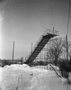
| Date: | 01 22 1949 |
|---|---|
| Description: | New junior ski jump at Hoyt Park. The jump is thirty-five feet high and is estimated to allow up to sixty-foot jumps under ideal conditions. |
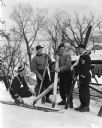
| Date: | 02 02 1949 |
|---|---|
| Description: | Four ski "jumpers" are posed on a hill with Lake Mendota behind them. They are, from left to right: Allen Bushnell, Wally Alcumbrac, Bill Bradley, and Don ... |
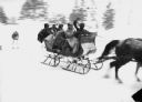
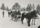
| Date: | 1930 |
|---|---|
| Description: | Winter scene with sleigh carrying six well-bundled passengers pulled by two horses and pulling a skier behind in Eagle River. The trees are blurred. |
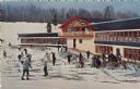
| Date: | |
|---|---|
| Description: | Color postcard of the Chalet at Mt. Telemark. Skiers and skis are in front of the Chalet. |
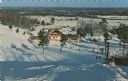
| Date: | |
|---|---|
| Description: | Color postcard of an elevated view of the Chalet at Mt. Telemark and surrounding area, and many skiers and several ski lifts. |

| Date: | 1918 |
|---|---|
| Description: | Outdoor view of a U.S. Army Engineer topographer wearing skis while using a tripod stand to write. The engineer is standing next to a barbed wire obstacle ... |
| Date: | |
|---|---|
| Description: | Winter scene with six well-bundled passengers in a sleigh pulled by two horses and pulling two skiers behind. In the background are pine trees. |

| Date: | |
|---|---|
| Description: | Winter scene looking down a hill towards skiers about to ski on the Capital Mississippi Alps near La Crosse, Wisconsin. La Crosse is in the background, and... |

| Date: | 1969 |
|---|---|
| Description: | This map shows ski areas, resorts, camps, special areas, airports, and roads. The map covers Vilas and Oneida counties and parts of Iron, Price, Lincoln, L... |

| Date: | 1962 |
|---|---|
| Description: | This map shows roads, golf courses, ski areas, boat landings, camp sites, waysides, parks, beaches, scenic views, virgin timber tracts, airports, boys and ... |

| Date: | 1960 |
|---|---|
| Description: | This pictorial map shows recreation activities, rivers, lakes, and the history of the area. The map covers Langlade County and parts of adjacent counties. ... |

| Date: | 1983 |
|---|---|
| Description: | This map covers Vilas county as well as parts of Iron, Oneida, and Forest counties. Club trails are shown in dotted red lines and state trails are shown in... |
| Date: | 02 2014 |
|---|---|
| Description: | Two boys playing on a snow-covered hill on a farm. There is a house in the background. One boy is sledding down the hill on a sled face first, while a dog ... |

| Date: | 1970 |
|---|---|
| Description: | This colored map displays detailed maps of Green Bay, Appleton, Racine, Milwaukee, Kenosha, and Duluth-Superior. At the top right is a map location list of... |

| Date: | 1971 |
|---|---|
| Description: | This colored map displays Wisconsin and bordering areas of Iowa, Minnesota, and Michigan. There is color-coding on the map to indicate National Forests, an... |

| Date: | 1973 |
|---|---|
| Description: | This colored map displays Wisconsin and bordering areas of Iowa, Minnesota, and Michigan. There is color-coding on the map to indicate National Forests, a... |

| Date: | 1975 |
|---|---|
| Description: | This colored road map of Wisconsin displays "Featured Points of Interest" and "Historical Points of Interest" in the state, including three color photograp... |

| Date: | 1976 |
|---|---|
| Description: | This colored map displays Wisconsin and portions of bordering states, including a detailed map of the Wisconsin Dells area. Surrounding the map are multipl... |

| Date: | 1977 |
|---|---|
| Description: | This colored map displays Wisconsin and portions of bordering states, including a detailed map of the Wisconsin Dells area. Surrounding the map are multipl... |

| Date: | 1973 |
|---|---|
| Description: | View across West Gorham Street, on the corner of North Broom Street, towards Ski/Cycle, a retail and service store for skis and bicycles. Skis and bicycles... |
If you didn't find the material you searched for, our Library Reference Staff can help.
Call our reference desk at 608-264-6535 or email us at: