 Filter: Categories of Wisconsin Historical Images
Filter: Subject of Sioux Indians
Filter: Subject of human settlements
Filter: Categories of Wisconsin Historical Images
Filter: Subject of Sioux Indians
Filter: Subject of human settlements
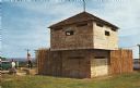
| Date: | 1960 |
|---|---|
| Description: | View of a stockade and blockhouse replica built on the site of the original stockade erected in 1862 during a small Sioux Indian uprising in nearby Minneso... |

| Date: | 1837 |
|---|---|
| Description: | This map shows planned military posts/depots, barracks, rivers, lakes, roads, existing forts, and land assigned to various Indian tribes. Arkansas, Illinoi... |

| Date: | 1705 |
|---|---|
| Description: | Map of America east of the Mississippi River showing boundaries, rivers, portages, forts, cities, villages, and Native American land. Annotations on early ... |
If you didn't find the material you searched for, our Library Reference Staff can help.
Call our reference desk at 608-264-6535 or email us at: