Filter: Categories of Wisconsin Historical Images
Filter: Subject of Signs and symbols
Filter: Subject of great lakes
Filter: Categories of Wisconsin Historical Images
Filter: Subject of Signs and symbols
Filter: Subject of great lakes

| Date: | 1670 |
|---|---|
| Description: | This map is in French and shows Lac Tracy ov Superieur (Lake Superior), Baye des Puans (Green Bay), and portions of Lac des Ilinois (Lake Michigan) and Lac... |

| Date: | 1970 |
|---|---|
| Description: | Aerial view of International Harvester's Wisconsin Steel Works, with a river and Lake Michigan in the background. |

| Date: | 1896 |
|---|---|
| Description: | Section 3 of 12, this bicycle road map features Wisconsin bicycle routes in the counties of Winnebago, Calumet, Manitowoc, Outagamie, Brown, Kewaunee, and ... |
| Date: | 1930 |
|---|---|
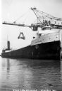
| Description: | View of the ship "Alex B. Uhrig" in the process of coal unloading on the Reiss Coal Dock No. 2. |
| Date: | |
|---|---|
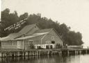
| Description: | View across water towards a group of people, men, woman, and young girls and boys, posing on a pier in front of a building on the shoreline of Sister Bay. ... |

| Date: | 1945 |
|---|---|
| Description: | Port of Kenosha Transit Warehouse No. 1. There are two ships on the right side, one named "Broom Park." Three men are loading a car onto the ship using a c... |
| Date: | 09 26 2014 |
|---|---|
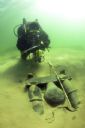
| Description: | Underwater view of an archaeologist surveying the bilge pump of the Success. The pump is resting in a bed of sand towards the stern of the ship. Tex... |

| Date: | 08 15 2014 |
|---|---|
| Description: | Underwater view of the capstan of the Success. The capstan is laying on its side embedded in the sand, near the stern on the starboard side of the s... |

| Date: | 1709 |
|---|---|
| Description: | Map of North America, showing a few of the largest settlements, regions, islands, and a few rivers. The Great Lakes are depicted, but over-sized, and Calif... |

| Date: | 1967 |
|---|---|
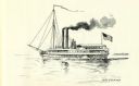
| Description: | View from behind of two men sitting on a park bench who are looking at the lake steamer docked in the harbor. In the distance, a red lighthouse is at the e... |
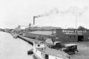
| Date: | 07 1936 |
|---|---|
| Description: | Elevated view of fishing tugs moored alongside the wharf at Marinette. Two automobiles are parked in the foreground, just in front of the Bridge Fish Co. b... |

| Date: | 1935 |
|---|---|
| Description: | View from shoreline towards fishing boats of various sizes, and sailboats docked at the wharf at Fish Creek. Two persons are carrying gear toward the pier.... |
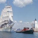
| Date: | 1964 |
|---|---|
| Description: | View across water towards the tugboat "Indiana" pulling the full-rigged, three-masted Norwegian ship "Christian Radich" into port. The sails and hull of th... |

| Date: | 01 10 1923 |
|---|---|
| Description: | Drawing of an aerial view of factory in Chatham, Ontario. |

| Date: | 1911 |
|---|---|
| Description: | Map of states in the United States, as well as inset maps of Russia, France, Germany and Sweden. At bottom right is a key for the map that includes: a numb... |
If you didn't find the material you searched for, our Library Reference Staff can help.
Call our reference desk at 608-264-6535 or email us at: