Filter: Categories of Wisconsin Historical Images
Filter: Subject of Signs and symbols
Filter: Subject of aerial photographs
Filter: Categories of Wisconsin Historical Images
Filter: Subject of Signs and symbols
Filter: Subject of aerial photographs
| Date: | |
|---|---|
| Description: | Aerial view of buildings with Lake Michigan in the distance. |
| Date: | |
|---|---|
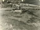
| Description: | The airfield of the Hamilton Aero Manufacturing Company which became the site of Milwaukee County Airport in 1926. It was established by Thomas Hamilton, a... |

| Date: | 08 20 1930 |
|---|---|
| Description: | Aerial view of the Madison skyline from University of Wisconsin Field House, overlooking the Wisconsin State Capitol and, in the foreground, Gateway Lumber... |

| Date: | 1957 |
|---|---|
| Description: | Aerial view of the north corner of Capitol Square looking toward Lake Mendota. The Belmont Hotel is featured prominently. |
| Date: | 1954 |
|---|---|
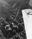
| Description: | Aerial view of the Wisconsin State Capitol, including a bit of the airplane wing. |

| Date: | 1955 |
|---|---|
| Description: | Aerial view of river and town from a military airplane. |

| Date: | 09 1918 |
|---|---|
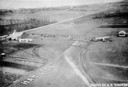
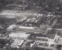
| Description: | Elevated view of the U.S. Government War Exposition grounds at Grant Park. |

| Date: | |
|---|---|
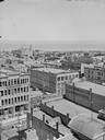
| Description: | Elevated view looking northeast from the roof of the Wells Building at E. Wisconsin Avenue and N. Milwaukee Street. St. John's Cathedral is in the center o... |
| Date: | |
|---|---|
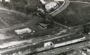
| Description: | Aerial view of University Avenue near the Veteran's Administration Hospital. At the bottom is the J.S. Timlin Lumber Company. |

| Date: | 1922 |
|---|---|
| Description: | Aerial view of downtown with City Hall and Milwaukee River. |

| Date: | 1947 |
|---|---|
| Description: | City Hall near the Milwaukee River. |
| Date: | 1961 |
|---|---|
| Description: | Aerial view of the Miller Electic Manufacturing Co. and surrounding area. |
| Date: | 1946 |
|---|---|
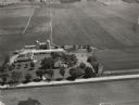
| Description: | Aerial view of farm which is part of the University of Wisconsin-Madison. In the foreground is a tree-lined road. The farm has several buildings, including... |

| Date: | 1970 |
|---|---|
| Description: | Aerial view of International Harvester's Wisconsin Steel Works, with a river and Lake Michigan in the background. |

| Date: | 1930 |
|---|---|
| Description: | Aerial view of International Harvester's Milwaukee Works. |

| Date: | 1959 |
|---|---|
| Description: | Aerial view of the island of Cuba taken from a small plane. Part of the plane with a Cuban flag painted on it is in the frame, and the island with many bui... |

| Date: | 1962 |
|---|---|
| Description: | Aerial view of four U.S. Marine helicopters banking over an expanse of rice paddies in Vietnam. Fluffy white clouds fill the sky. |

| Date: | |
|---|---|
| Description: | An aerial view of Governor's Island. A cutout of an arrow has been added. |
If you didn't find the material you searched for, our Library Reference Staff can help.
Call our reference desk at 608-264-6535 or email us at: