 Filter: Categories of Wisconsin Historical Images
Filter: Subject of Shorelines
Filter: Year of 1800-1899
Filter: Subject of intellectual life
Filter: Categories of Wisconsin Historical Images
Filter: Subject of Shorelines
Filter: Year of 1800-1899
Filter: Subject of intellectual life
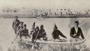
| Date: | 1860 |
|---|---|
| Description: | Nine men arrive at Fort William by canoe. Fort William, also called Kaministiguia, was the Hudson's Bay fur trading post. Men are standing along the opposi... |

| Date: | 1856 |
|---|---|
| Description: | View looking west from Lake Michigan with several steam ships and sailing vessels in harbor. There is a lighthouse to left of center, along shoreline. |

| Date: | 1872 |
|---|---|
| Description: | Bird's-eye map of Milwaukee on Lake Michigan. |

| Date: | 1886 |
|---|---|
| Description: | Bird's-eye map of Washburn on Lake Superior. There is an inset of Washburn, Chequamagon and the Apostle Islands. |

| Date: | 1898 |
|---|---|
| Description: | Bird's-eye map, looking west from shoreline on Lake Michigan of Milwaukee to Golden Lake in Waukesha County, with Kenosha and Fox Point at bottom corners, ... |

| Date: | 1874 |
|---|---|
| Description: | Bird's-eye map of Racine, with an inset of Racine College. |

| Date: | 1886 |
|---|---|
| Description: | Bird's-eye view of Milwaukee from Bay View. |

| Date: | 1875 |
|---|---|
| Description: | Aerial view of Alma along Mississippi River, with bluffs along the horizon. |
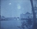
| Date: | 1893 |
|---|---|
| Description: | A cyanotype view across lagoon from shoreline of the U.S. Government Building (right), and the Fisheries building (left). There is a bridge over the lagoon... |

| Date: | 1891 |
|---|---|
| Description: | Color illustration of the grounds and buildings of the 1893 World's Fair or Columbian Exposition. |
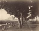
| Date: | 1890 |
|---|---|
| Description: | View down road lined with trees in Egypt. A group of Egyptians are standing and sitting between the trees and the river, and travelers on the road are walk... |

| Date: | 1836 |
|---|---|
| Description: | A detailed map of the mouth of the Kewaunee River, showing the geological composition of the Lake Michigan shoreline and the various water depths in the ar... |

| Date: | 1881 |
|---|---|
| Description: | Bird's-eye view of Milwaukee from the south lakeshore. |
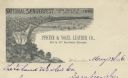
| Date: | 1886 |
|---|---|
| Description: | Letterhead for the Pfister & Vogel Leather Co., with an engraving of a bird's-eye view of the city (signed Ma-- Richards, Mil Wis) advertising the "Nationa... |
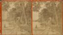
| Date: | 1890 |
|---|---|
| Description: | Stereograph view along shoreline of Geneva Lake at Porter's Park. A man sits in a canoe at the rocky shoreline while a woman sits and reads on a rustic ben... |

| Date: | 1874 |
|---|---|
| Description: | Birds-eye view of Appleton Wisconsin. In the foreground are people fishing, strolling, and looking over the canal towards the Fox River. Streets and buildi... |
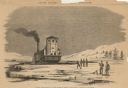
| Date: | 1859 |
|---|---|
| Description: | Engraved drawing of Norman Wiard's ice locomotive, Lady Franklin being pulled from water onto ice using its anchor. The vessel was built, but never ... |

| Date: | 1893 |
|---|---|
| Description: | View of a replica Viking Ship that sailed from Norway to the United States for the Columbian Exposition in 1893. Three men are standing on shore in front o... |
If you didn't find the material you searched for, our Library Reference Staff can help.
Call our reference desk at 608-264-6535 or email us at: