 Filter: Categories of Wisconsin Historical Images
Filter: Subject of Shorelines
Filter: Subject of transportation
Filter: Type of Map or Atlas
Filter: Categories of Wisconsin Historical Images
Filter: Subject of Shorelines
Filter: Subject of transportation
Filter: Type of Map or Atlas

| Date: | 1856 |
|---|---|
| Description: | View looking west from Lake Michigan with several steam ships and sailing vessels in harbor. There is a lighthouse to left of center, along shoreline. |

| Date: | 1872 |
|---|---|
| Description: | Bird's-eye map of Milwaukee on Lake Michigan. |

| Date: | 1915 |
|---|---|
| Description: | Bird's-eye view of Superior, Wisconsin, and Duluth, Minnesota on opposite shore of Lake Superior. |

| Date: | 1886 |
|---|---|
| Description: | Bird's-eye map of Washburn on Lake Superior. There is an inset of Washburn, Chequamagon and the Apostle Islands. |

| Date: | 1898 |
|---|---|
| Description: | Bird's-eye map, looking west from shoreline on Lake Michigan of Milwaukee to Golden Lake in Waukesha County, with Kenosha and Fox Point at bottom corners, ... |

| Date: | 1874 |
|---|---|
| Description: | Bird's-eye map of Racine, with an inset of Racine College. |

| Date: | 1839 |
|---|---|
| Description: | Map of a canal route to avoid the principal rapids of the Neenah or Fox River between Lake Winnebago and Green Bay. |

| Date: | 1778 |
|---|---|
| Description: | This Italian map from 1778 depicts the upper portion of the Old Northwest. Rivers and lakes are identified and relief, real and imagined, is depicted picto... |

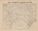
| Date: | 1862 |
|---|---|
| Description: | This map of the southeastern United States shows forts and battlefields, railroads, rivers, and cities and towns. Dates of admission and secession of the s... |
| Date: | |
|---|---|
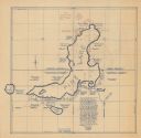
| Description: | Map covering most of Georgia and South Carolina, showing defenses along the seacoast and around the principal towns, Confederate prisons at Andersonville a... |

| Date: | 1836 |
|---|---|
| Description: | A detailed map of the mouth of the Kewaunee River, showing the geological composition of the Lake Michigan shoreline and the various water depths in the ar... |

| Date: | 1899 |
|---|---|
| Description: | A map showing the shoreline of a portion of El Montecito, Santa Barbara County, California. The map shows properties along the Pacific Ocean, and may have ... |

| Date: | 1875 |
|---|---|
| Description: | This manuscript map by Increase Lapham, drawn in the last year of his life, shows landownership, roads and railroads, springs, and boat houses around Ocono... |

| Date: | 1909 |
|---|---|
| Description: | This 1909 chart of the Apostle Islands, Chequamegon Bay, and the Lake Superior shoreline shows relief by contours and spot heights and depths by contours, ... |

| Date: | 1938 |
|---|---|
| Description: | This tourist map of Door County, Wisconsin, lists the points of interest and resorts in the area. An inset location map is included. |

| Date: | 1930 |
|---|---|
| Description: | "Issued by Door County Chamber of Commerce." Shows federal system highways, state highways, county trunk highways, country roads, and parks. Includes direc... |
| Date: | 1935 |
|---|---|
| Description: | This map shows property owners, government lots, and roads around Pine Lake in Rusk and Chippewa Counties. Also shows Silver and McDonald Lakes. "This map ... |

| Date: | 1836 |
|---|---|
| Description: | This map is pen-and-ink on paper and shows marshlands, rivers, creeks, a quarry, and a few roads. |

| Date: | 1900 |
|---|---|
| Description: | This map of West Navarino shows plat of the town, lots by number, local streets, public square, The Fox River, and Fort Howard. The bottom of the map reads... |

| Date: | 1881 |
|---|---|
| Description: | Bird's-eye view of Milwaukee from the south lakeshore. |
If you didn't find the material you searched for, our Library Reference Staff can help.
Call our reference desk at 608-264-6535 or email us at: