 Filter: Categories of Wisconsin Historical Images
Filter: Subject of Shorelines
Filter: Subject of streets
Filter: Categories of Wisconsin Historical Images
Filter: Subject of Shorelines
Filter: Subject of streets

| Date: | 1950 |
|---|---|
| Description: | Aerial view of the Wisconsin State Capitol building and surrounding Madison area. Lake Monona is in the background. |

| Date: | 07 10 1949 |
|---|---|
| Description: | Aerial view of Minocqua showing the surrounding lakes. |

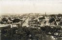
| Date: | 05 09 1908 |
|---|---|
| Description: | Kite aerial panoramic photograph of the central business district. In the distance is Lake Mendota. The fire damaged Wisconsin State Capitol is in the cent... |
| Date: | 1890 |
|---|---|
| Description: | Looking south from the capitol dome of the Wisconsin State Capitol, the view is of West Main Street bound by South Hamilton Street and Monona Avenue (now M... |

| Date: | 1872 |
|---|---|
| Description: | Bird's-eye map of Milwaukee on Lake Michigan. |
| Date: | 03 01 1937 |
|---|---|
| Description: | View of frozen Lake Monona from the fifth floor window of the Cardinal Hotel. Shows the "Monona Community Assn. Inc./Lake Sports Promotion!" building, incl... |

| Date: | 1874 |
|---|---|
| Description: | Bird's-eye map of Racine, with an inset of Racine College. |
| Date: | 1889 |
|---|---|
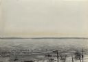
| Description: | Southwest view of the Fox River and the waterfront. |

| Date: | 1874 |
|---|---|
| Description: | View of the University of Wisconsin-Madison from the Wisconsin State Capitol. |
| Date: | 1939 |
|---|---|
| Description: | The proposed Mendota Lake Front Development Plan, William Kaeser, architect. |
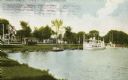
| Date: | 1908 |
|---|---|
| Description: | View from shoreline towards a large boat, perhaps an excursion boat, and sailboats docked further down along the curving shoreline. Beyond the boats is a t... |
| Date: | |
|---|---|
| Description: | View of Eagle Harbor and the area surrounding Church Street. On the right, Ephraim Moravian Church, completed in 1859, can be seen among residential buildi... |

| Date: | |
|---|---|
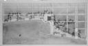
| Description: | Elevated view down Beach Boulevard, a boardwalk-like street with gift shops and carnival events facing the beach and harbor. Crowds of people are on the si... |
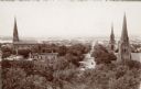
| Date: | 1905 |
|---|---|
| Description: | Elevated view down West Washington Avenue from the roof of the Wisconsin State Capitol. Three churches are seen, from left: St. Raphael Catholic Church, Fi... |
| Date: | 1905 |
|---|---|
| Description: | Elevated view from the roof of the Wisconsin State Capitol looking west along State Street to Bascom Hall (with dome). The State Historical Society Buildin... |

| Date: | 1972 |
|---|---|
| Description: | Political scientist Samuel L. Popkin and his wife. This photograph was taken about the time Wisconsin-born Popkin was jailed for his refusal to testify abo... |
| Date: | 1938 |
|---|---|
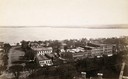
| Description: | Large vacation homes in La Pointe, Madeline Island. Bayfield is in the background on the far shore of Lake Superior. |

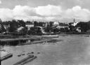
| Date: | |
|---|---|
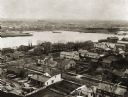
| Description: | General view of the city, built into a hillside. The monumental building near the shore is the United States Courthouse, built in 1903. Published by Wint... |

| Date: | 04 12 1907 |
|---|---|
| Description: | Photographic postcard of an aerial view of town looking North. The Mississippi River is on the left. |

| Date: | |
|---|---|
| Description: | Elevated view of the business district showing Tongass Narrows in the background. |
If you didn't find the material you searched for, our Library Reference Staff can help.
Call our reference desk at 608-264-6535 or email us at: