 Filter: Categories of Wisconsin Historical Images
Filter: Subject of Shorelines
Filter: Subject of research
Filter: Categories of Wisconsin Historical Images
Filter: Subject of Shorelines
Filter: Subject of research
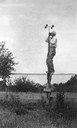
| Date: | 1912 |
|---|---|
| Description: | Dr. E.A. Birge in his element, reading an anemometer of the weather data station on Green Lake. |

| Date: | 1956 |
|---|---|
| Description: | Aerial view over University Avenue of the University of Wisconsin-Madison campus, including University farm in the upper middle. The shoreline of Lake Mend... |

| Date: | 01 13 1937 |
|---|---|
| Description: | Sketch map of Township 7 North, Range 9 East, created for the Land Economic Inventory (Bordner Survey). The map shows Picnic Point and the Lake Mendota sho... |
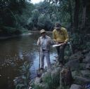
| Date: | 10 1978 |
|---|---|
| Description: | Two men are standing on the rocky shoreline of the Sheboygan River. One man is holding a shovel in his right hand and a glass jar in his left hand. The oth... |
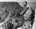
| Date: | 07 21 1985 |
|---|---|
| Description: | View of a man and a woman looking over a railing, with binoculars and a telescopic lens at hand. Caption reads: "Light keeper John Foote and researcher Lau... |
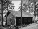
| Date: | 1935 |
|---|---|
| Description: | View looking down slope towards the Bacteriology Laboratory on the shore of Trout Lake. Trees are around the small, wood sided building, and the lake is in... |
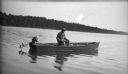
| Date: | 1930 |
|---|---|
| Description: | Dr. Birge sitting in a boat, probably at Trout Lake. The outboard motor on the boat has been tilted out of the water. A wooded shoreline is in the distance... |
If you didn't find the material you searched for, our Library Reference Staff can help.
Call our reference desk at 608-264-6535 or email us at: