 Filter: Categories of Wisconsin Historical Images
Filter: Subject of Ships
Filter: Subject of streets
Filter: Categories of Wisconsin Historical Images
Filter: Subject of Ships
Filter: Subject of streets

| Date: | 1881 |
|---|---|
| Description: | Bird's-eye map of Marinette, with insets. |

| Date: | 1890 |
|---|---|
| Description: | Bird's-eye map of Ashland, viewed from Lake Superior, with insets of Prentice Park and Fishery. Population 16,000. Increase in Ten Years, 11,000. |

| Date: | 1853 |
|---|---|
| Description: | Bird's-eye map of Milwaukee looking east toward Lake Michigan from a bluff, long since graded into a slope, at about 6th Street between Wisconsin Avenue an... |
| Date: | |
|---|---|
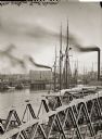
| Description: | Elevated view of Milwaukee River from Walker's Point Bridge. |
| Date: | |
|---|---|
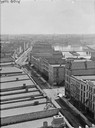
| Description: | Milwaukee, south from Mitchell Block. View shows rooftops and building fronts. Ships and bridge are in the background on the right. |

| Date: | 1867 |
|---|---|
| Description: | Bird's-eye map of Green Bay and Fort Howard, Brown Co., depicts street names and street layouts, houses, trees, and the East River. A reference key at the ... |

| Date: | 1873 |
|---|---|
| Description: | Bird's-eye map of La Crosse from the Mississippi River. |

| Date: | 1898 |
|---|---|
| Description: | Bird's-eye map of Milwaukee with prominent streets and buildings identified. Taken from City Hall Tower. |

| Date: | 1872 |
|---|---|
| Description: | Bird's-eye map of Milwaukee on Lake Michigan. |

| Date: | 1874 |
|---|---|
| Description: | Bird's-eye map of Chippewa Falls. |

| Date: | 1877 |
|---|---|
| Description: | Bird's-eye map of Janesville on the Rock River. |

| Date: | 1896 |
|---|---|
| Description: | Bird's-eye view of Washburn, with twenty vignettes around side, water in foreground with docks and lumber corral. Thirty-three locations identified in key ... |

| Date: | 1892 |
|---|---|
| Description: | Bird's-eye view of Chicago, with ships in the Lake Michigan harbor. |
| Date: | 1875 |
|---|---|
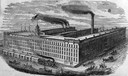
| Description: | Drawing of the C.H. & L.J. McCormick Reaper Manufactory (McCormick Reaper Works). The factory was built after the Chicago Fire of 1871 destroyed the origin... |

| Date: | 1854 |
|---|---|
| Description: | Bird's-eye illustration of Milwaukee. |
| Date: | 1910 |
|---|---|
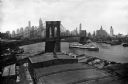
| Description: | View of the East River and the Brooklyn Bridge. Several boats and ships sail down the river and industrial buildings and skyscrapers stand in the foregroun... |

| Date: | |
|---|---|
| Description: | Bird's-eye view lithograph of Key West with ships and smaller boats in the surrounding waters. |

| Date: | |
|---|---|
| Description: | Elevated general view of the city with harbor and mountains. A ship is docked near the railroad bridge. |
If you didn't find the material you searched for, our Library Reference Staff can help.
Call our reference desk at 608-264-6535 or email us at:

