 Filter: Categories of Wisconsin Historical Images
Filter: Subject of Ships
Filter: Subject of landforms
Filter: Categories of Wisconsin Historical Images
Filter: Subject of Ships
Filter: Subject of landforms
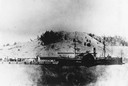
| Date: | |
|---|---|
| Description: | The sidewheel passenger and freight, "Milwaukee," at Dewey Hill, Grand Haven, Michigan, at the Detroit, Grand Haven and Milwaukee Railway depot. |

| Date: | 1867 |
|---|---|
| Description: | Birds-eye drawing of Appleton, Outagamie Co., depicting street names and street layout, houses, the Fox River, the court house, jail, school houses, Lawren... |

| Date: | 1867 |
|---|---|
| Description: | Bird's-eye map of Green Bay and Fort Howard, Brown Co., depicts street names and street layouts, houses, trees, and the East River. A reference key at the ... |

| Date: | 1874 |
|---|---|
| Description: | Bird's-eye map of Chippewa Falls. |

| Date: | 1877 |
|---|---|
| Description: | Bird's-eye map of Janesville on the Rock River. |

| Date: | 1898 |
|---|---|
| Description: | Bird's-eye map, looking west from shoreline on Lake Michigan of Milwaukee to Golden Lake in Waukesha County, with Kenosha and Fox Point at bottom corners, ... |

| Date: | 1892 |
|---|---|
| Description: | Bird's-eye view of Chicago, with ships in the Lake Michigan harbor. |

| Date: | 1866 |
|---|---|
| Description: | Exterior of Fort Sumter. A cannon has fallen on the steep shoreline and waves are hitting the rocks. Plate 58 |

| Date: | 1893 |
|---|---|
| Description: | Bird’s-eye view of Depere looking North. Includes illustrations and an index to points of interest. |
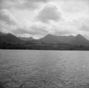
| Date: | 08 11 1943 |
|---|---|
| Description: | A view of Milne Bay, New Guinea (present day Papua New Guinea), from the sea. A ship can be seen on the right, at the shoreline. |

| Date: | 1918 |
|---|---|
| Description: | Map showing Aleppo, Zor, Syria, Lebanon, Beirut, Jerusalem, with an inset map of the Sinai Peninsula and Egyptian frontier. Also shows the locations of rai... |

| Date: | 09 04 1885 |
|---|---|
| Description: | Exterior and interior bill of fare from The Chequamegon, with views on the back of rock formations, waterfalls, a spot illustration of a train going over a... |

| Date: | |
|---|---|
| Description: | Letterhead of Johnson & Melaas, merchant tailors and cloth dealers, "Buyers of wool and Wisconsin leaf tobacco," with an engraving of a waterfront view of ... |
If you didn't find the material you searched for, our Library Reference Staff can help.
Call our reference desk at 608-264-6535 or email us at:
