 Filter: Categories of Wisconsin Historical Images
Filter: Subject of Ships
Filter: Subject of intellectual life
Filter: Subject of michigan, lake
Filter: Categories of Wisconsin Historical Images
Filter: Subject of Ships
Filter: Subject of intellectual life
Filter: Subject of michigan, lake

| Date: | 1871 |
|---|---|
| Description: | Bird's-eye view of the Chicago fire of October 8, 1871. The hand-colored lithograph was published by Currier and Ives. |

| Date: | 1853 |
|---|---|
| Description: | Bird's-eye map of Milwaukee looking east toward Lake Michigan from a bluff, long since graded into a slope, at about 6th Street between Wisconsin Avenue an... |

| Date: | 1898 |
|---|---|
| Description: | Bird's-eye map of Milwaukee with prominent streets and buildings identified. Taken from City Hall Tower. |

| Date: | 1872 |
|---|---|
| Description: | Bird's-eye map of Milwaukee on Lake Michigan. |

| Date: | 1883 |
|---|---|
| Description: | Bird's-eye map of Manitowoc. |

| Date: | 1898 |
|---|---|
| Description: | Bird's-eye map, looking west from shoreline on Lake Michigan of Milwaukee to Golden Lake in Waukesha County, with Kenosha and Fox Point at bottom corners, ... |

| Date: | 1879 |
|---|---|
| Description: | Bird's-eye map of Two Rivers. |

| Date: | 1886 |
|---|---|
| Description: | Bird's-eye view of Milwaukee from Bay View. |

| Date: | 1892 |
|---|---|
| Description: | Bird's-eye view of Chicago, with ships in the Lake Michigan harbor. |

| Date: | 1892 |
|---|---|
| Description: | Bird's-eye view of the Columbian Exposition pavilions from the vantage point of Lake Michigan. Included is an inset of the Union Passenger Station (now Uni... |

| Date: | 1854 |
|---|---|
| Description: | Bird's-eye illustration of Milwaukee. |
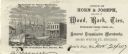
| Date: | |
|---|---|
| Description: | Letterhead of the Horn's Pier (Door County) office of Horn & Joseph, dealers in general merchandise, including "Wood, Bark, Ties, Telegraph Poles, Posts, &... |

| Date: | 1874 |
|---|---|
| Description: | A hand-colored, geological map of Wisconsin show the progress of the state geological survey in 1873 and 1874. Other elements displayed in the map include... |

| Date: | 1930 |
|---|---|
| Description: | Aerial view from over Moonlight Bay, looking east across Bues Point to Spike Horn Bay and Cana Island. The Cana Island Lighthouse is seen as a ship passes ... |

| Date: | 1881 |
|---|---|
| Description: | Bird's-eye view of Milwaukee from the south lakeshore. |

| Date: | 06 14 1961 |
|---|---|
| Description: | Aerial view of North and South Harbor Tracts, looking north from South Pier No. 2. There are skyscrapers in the background. there are multiple items of mac... |
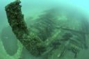
| Date: | 2015 |
|---|---|
| Description: | Underwater view of algae and mussels covering the wood skeletal frame of the Advance, a schooner built in 1853 and sunk in 1885. Most of the frame i... |

| Date: | 2014 |
|---|---|
| Description: | Underwater view of pieces of the schooner Advance laying on the haul of the ship at the bottom of Lake Michigan. |

| Date: | 2008 |
|---|---|
| Description: | Underwater view of the stern of the schooner Home resting on the bottom of Lake Michigan. One of the masts is broken and is bending over the port si... |

| Date: | 06 12 2008 |
|---|---|
| Description: | Underwater view of the bow of the schooner Home. The port anchor is hanging along the port side of the ship. The bowsprit is laying on the lake bed ... |
If you didn't find the material you searched for, our Library Reference Staff can help.
Call our reference desk at 608-264-6535 or email us at: