 Filter: Categories of Wisconsin Historical Images
Filter: Subject of Ships
Filter: Subject of intellectual life
Filter: Community of Ashland
Filter: Categories of Wisconsin Historical Images
Filter: Subject of Ships
Filter: Subject of intellectual life
Filter: Community of Ashland

| Date: | 1886 |
|---|---|
| Description: | Bird's-eye view of Ashland, on the shores of Lake Superior, with insets of The Apostle Islands Chequamagon Bay & Ashland, and Distances from Ashland. |

| Date: | 1890 |
|---|---|
| Description: | Bird's-eye map of Ashland, viewed from Lake Superior, with insets of Prentice Park and Fishery. Population 16,000. Increase in Ten Years, 11,000. |

| Date: | |
|---|---|
| Description: | Looking West from Knight Block, with shipping piers and sailing ships on right side, railroad on left, trees in background. Horse-drawn carriages on street... |
| Date: | |
|---|---|
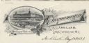
| Description: | Letterhead of the Chequamegon Hotel of Ashland, on Lake Superior, with a three-quarter view of the hotel, as seen from the waterfront, set into a cartouche... |

| Date: | |
|---|---|
| Description: | Aerial view of town, showing the shoreline of Lake Superior, ore docks, roads, houses, buildings, trees, and smokestacks. Text describing this photograph s... |

| Date: | 09 04 1885 |
|---|---|
| Description: | Exterior and interior bill of fare from The Chequamegon, with views on the back of rock formations, waterfalls, a spot illustration of a train going over a... |
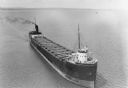
| Date: | 1935 |
|---|---|
| Description: | Aerial view of crew members standing and sitting on the deck of the ore boat Captain Thomas Wilson in Ashland harbor. |
If you didn't find the material you searched for, our Library Reference Staff can help.
Call our reference desk at 608-264-6535 or email us at: