 Filter: Categories of Wisconsin Historical Images
Filter: Subject of Ships
Filter: County of Brown
Filter: Subject of rivers
Filter: Categories of Wisconsin Historical Images
Filter: Subject of Ships
Filter: County of Brown
Filter: Subject of rivers

| Date: | 1867 |
|---|---|
| Description: | Bird's-eye map of Green Bay and Fort Howard, Brown Co., depicts street names and street layouts, houses, trees, and the East River. A reference key at the ... |

| Date: | 1876 |
|---|---|
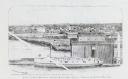
| Description: | Elevated view showing Elmore and Kelly's Elevator with a boat, train, and the buildings at Fort Howard. Fort Howard was incorporated into Green Bay. Captio... |
| Date: | 1910 |
|---|---|
| Description: | Slightly elevated view of the Fox River, with a bridge and ship in the river. |
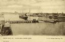
| Date: | 1900 |
|---|---|
| Description: | Looking North. Harbor with boats, bridge, and buildings. |
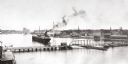
| Date: | 1850 |
|---|---|
| Description: | Elevated view of the Green Bay harbor and docks. |
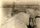
| Date: | 1876 |
|---|---|
| Description: | View looking southeast over river from Elmore and Kelly's Elevator. |

| Date: | 1889 |
|---|---|
| Description: | View of the Fox River between Green Bay and Fort Howard. |
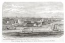
| Date: | 1876 |
|---|---|
| Description: | Drawing of a ship being loaded by Elmore & Kelly's Elevator on Fort Howard River looking north. A town and a train are in the background. |

| Date: | 1893 |
|---|---|
| Description: | Bird’s-eye view of Depere looking North. Includes illustrations and an index to points of interest. |
If you didn't find the material you searched for, our Library Reference Staff can help.
Call our reference desk at 608-264-6535 or email us at:
