Filter: Categories of Wisconsin Historical Images
Filter: Subject of Ships
Filter: Community of Washburn
Filter: Categories of Wisconsin Historical Images
Filter: Subject of Ships
Filter: Community of Washburn

| Date: | 1886 |
|---|---|
| Description: | Bird's-eye map of Washburn on Lake Superior. There is an inset of Washburn, Chequamagon and the Apostle Islands. |

| Date: | 1896 |
|---|---|
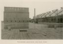
| Description: | Bird's-eye view of Washburn, with twenty vignettes around side, water in foreground with docks and lumber corral. Thirty-three locations identified in key ... |
| Date: | 1936 |
|---|---|
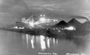
| Description: | Unloading coal from a large ship in Lake Superior onto land near Washburn. There is a large conveyor that has lights glowing in the dark sky. A large pile ... |
| Date: | |
|---|---|
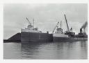
| Description: | View across water towards ships unloading coal and sulphur. Cranes rise above both ships, and a man is walking near a large pile of coal in the background ... |
| Date: | |
|---|---|
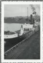
| Description: | Elevated view over railroads tracks of Canadian ship with cargo of wood pulp. Sulphide bales are being unloaded and there are several men on the ship. In t... |
If you didn't find the material you searched for, our Library Reference Staff can help.
Call our reference desk at 608-264-6535 or email us at: