 Filter: Categories of Wisconsin Historical Images
Filter: Subject of Shipping
Filter: County of Milwaukee
Filter: Categories of Wisconsin Historical Images
Filter: Subject of Shipping
Filter: County of Milwaukee

| Date: | 06 14 1961 |
|---|---|
| Description: | Aerial view of North and South Harbor Tracts, looking north from South Pier No. 2. There are skyscrapers in the background. there are multiple items of mac... |

| Date: | 1902 |
|---|---|
| Description: | This map is a chart of Milwaukee Harbor that displays local streets, bridges, roads, railroads, public buildings, businesses, factories, dry docks, parks, ... |
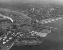
| Date: | 1952 |
|---|---|
| Description: | Aerial view of the harbor and port facilities. |
If you didn't find the material you searched for, our Library Reference Staff can help.
Call our reference desk at 608-264-6535 or email us at: