 Filter: Categories of Wisconsin Historical Images
Filter: Subject of Shipping
Filter: Creator Name of Unknown
Filter: County of Douglas
Filter: Categories of Wisconsin Historical Images
Filter: Subject of Shipping
Filter: Creator Name of Unknown
Filter: County of Douglas

| Date: | 1890 |
|---|---|
| Description: | Bird's-eye map of West Superior and Superior, with insets of Wright Farm and First Building in Superior. |

| Date: | 1890 |
|---|---|
| Description: | This map of Superior shows city wards, bays, docks, some businesses and points of interest. Relief is shown by hachures. The back of the map features a typ... |

| Date: | 1951 |
|---|---|
| Description: | This map of Superior shows labeled streets, waterways, railroads, and company ownership of docks. |
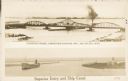
| Date: | 1907 |
|---|---|
| Description: | Postcard with two images. The top text reads: "Interstate Bridge, connecting Superior, Wis. and Duluth, Minn." The bottom text reads: "Superior Entry and S... |
If you didn't find the material you searched for, our Library Reference Staff can help.
Call our reference desk at 608-264-6535 or email us at: